You are here: Home > Network List > TA - USArray Transportable Network (new EarthScope stations) Stations List
> Station M11K Mekoryuk, AK, USA > Earthquake Result Viewer
M11K Mekoryuk, AK, USA - Earthquake Result Viewer
| Earthquake location: |
Iran-Iraq Border Region |
| Earthquake latitude/longitude: |
34.9/46.0 |
| Earthquake time(UTC): |
2017/11/12 (316) 18:18:17 GMT |
| Earthquake Depth: |
19 km |
| Earthquake Magnitude: |
7.3 Mww |
| Earthquake Catalog/Contributor: |
NEIC PDE/us |
|
| Network: |
TA USArray Transportable Network (new EarthScope stations) |
| Station: |
M11K Mekoryuk, AK, USA |
| Lat/Lon: |
60.38 N/166.20 W |
| Elevation: |
3.0 m |
|
| Distance: |
81.4 deg |
| Az: |
15.506 deg |
| Baz: |
333.744 deg |
| Ray Param: |
0.047567356 |
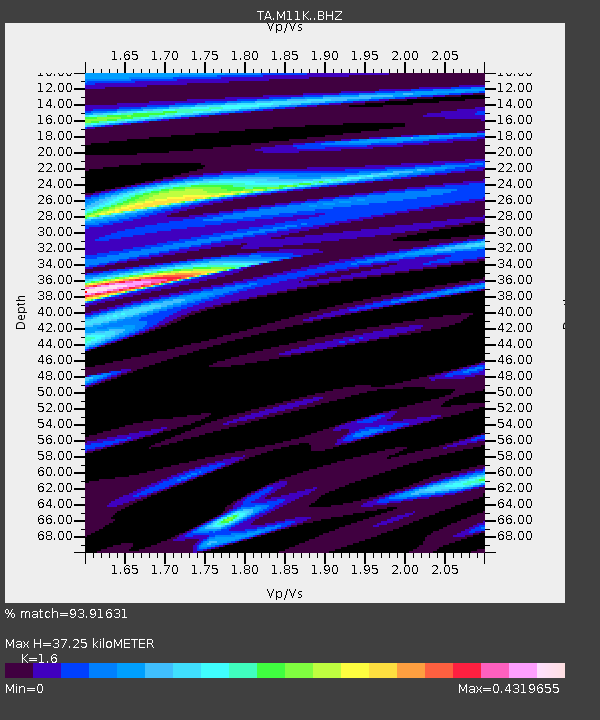
| Estimated Moho Depth: |
37.25 km |
| Estimated Crust Vp/Vs: |
1.60 |
| Assumed Crust Vp: |
6.134 km/s |
| Estimated Crust Vs: |
3.834 km/s |
| Estimated Crust Poisson's Ratio: |
0.18 |
|
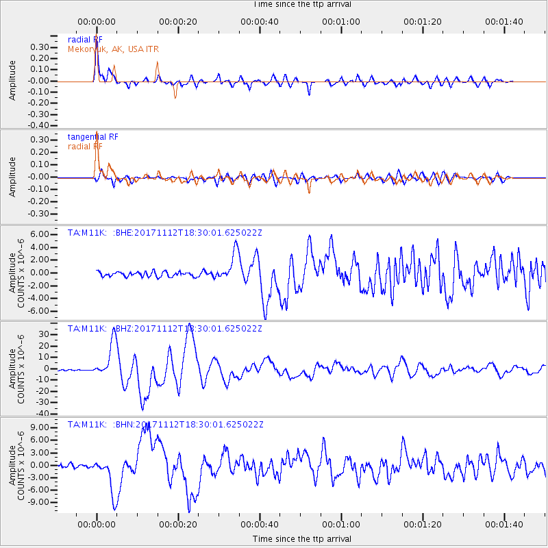
| Radial Match: |
93.91631 % |
| Radial Bump: |
400 |
| Transverse Match: |
78.16195 % |
| Transverse Bump: |
400 |
| SOD ConfigId: |
13570011 |
| Insert Time: |
2019-04-29 04:34:49.055 +0000 |
| GWidth: |
2.5 |
| Max Bumps: |
400 |
| Tol: |
0.001 |
|
Signal To Noise
| Channel | StoN | STA | LTA |
| TA:M11K: :BHZ:20171112T18:30:01.625022Z | 26.668987 | 1.6690039E-5 | 6.2582205E-7 |
| TA:M11K: :BHN:20171112T18:30:01.625022Z | 11.690231 | 4.5441507E-6 | 3.8871352E-7 |
| TA:M11K: :BHE:20171112T18:30:01.625022Z | 6.295567 | 2.3207388E-6 | 3.6863062E-7 |
| Arrivals |
| Ps | 3.7 SECOND |
| PpPs | 15 SECOND |
| PsPs/PpSs | 19 SECOND |


