You are here: Home > Network List > TA - USArray Transportable Network (new EarthScope stations) Stations List
> Station MDND Maddock, ND, USA > Earthquake Result Viewer
MDND Maddock, ND, USA - Earthquake Result Viewer

| Earthquake location: |
Iran-Iraq Border Region |
| Earthquake latitude/longitude: |
34.9/46.0 |
| Earthquake time(UTC): |
2017/11/12 (316) 18:18:17 GMT |
| Earthquake Depth: |
19 km |
| Earthquake Magnitude: |
7.3 Mww |
| Earthquake Catalog/Contributor: |
NEIC PDE/us |
|
| Network: |
TA USArray Transportable Network (new EarthScope stations) |
| Station: |
MDND Maddock, ND, USA |
| Lat/Lon: |
47.85 N/99.60 W |
| Elevation: |
479 m |
|
| Distance: |
92.0 deg |
| Az: |
337.593 deg |
| Baz: |
27.718 deg |
| Ray Param: |
0.04151596 |
| Estimated Moho Depth: |
33.0 km |
| Estimated Crust Vp/Vs: |
1.95 |
| Assumed Crust Vp: |
6.53 km/s |
| Estimated Crust Vs: |
3.353 km/s |
| Estimated Crust Poisson's Ratio: |
0.32 |
|
| Radial Match: |
85.080215 % |
| Radial Bump: |
400 |
| Transverse Match: |
48.73313 % |
| Transverse Bump: |
345 |
| SOD ConfigId: |
13570011 |
| Insert Time: |
2019-04-29 04:35:03.603 +0000 |
| GWidth: |
2.5 |
| Max Bumps: |
400 |
| Tol: |
0.001 |
|
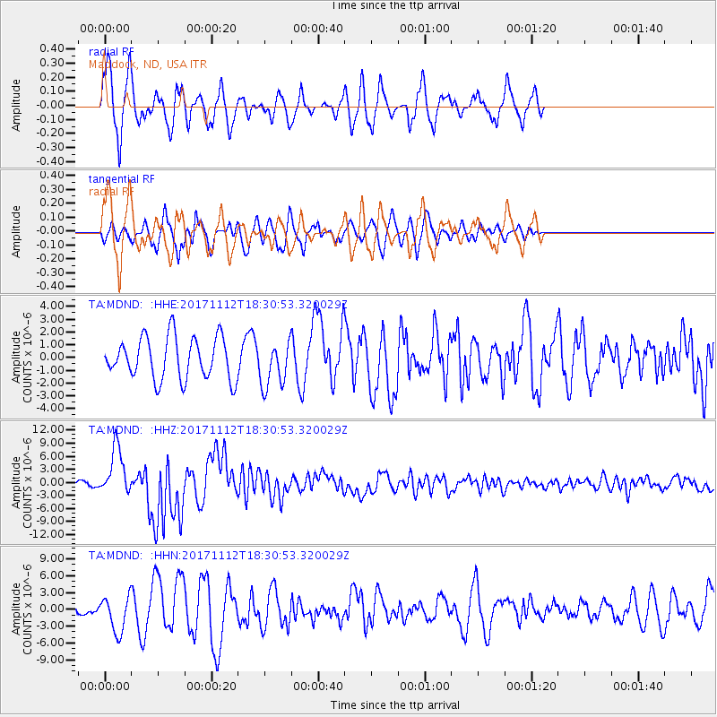
Signal To Noise
| Channel | StoN | STA | LTA |
| TA:MDND: :HHZ:20171112T18:30:53.320029Z | 10.668493 | 5.598556E-6 | 5.2477475E-7 |
| TA:MDND: :HHN:20171112T18:30:53.320029Z | 2.8863928 | 3.1925426E-6 | 1.1060666E-6 |
| TA:MDND: :HHE:20171112T18:30:53.320029Z | 1.0843729 | 1.7706292E-6 | 1.6328602E-6 |
| Arrivals |
| Ps | 4.9 SECOND |
| PpPs | 15 SECOND |
| PsPs/PpSs | 19 SECOND |


