You are here: Home > Network List > TA - USArray Transportable Network (new EarthScope stations) Stations List
> Station N25K Chitina, Valdez-Cordova, AK, USA > Earthquake Result Viewer
N25K Chitina, Valdez-Cordova, AK, USA - Earthquake Result Viewer
| Earthquake location: |
Iran-Iraq Border Region |
| Earthquake latitude/longitude: |
34.9/46.0 |
| Earthquake time(UTC): |
2017/11/12 (316) 18:18:17 GMT |
| Earthquake Depth: |
19 km |
| Earthquake Magnitude: |
7.3 Mww |
| Earthquake Catalog/Contributor: |
NEIC PDE/us |
|
| Network: |
TA USArray Transportable Network (new EarthScope stations) |
| Station: |
N25K Chitina, Valdez-Cordova, AK, USA |
| Lat/Lon: |
61.61 N/144.60 W |
| Elevation: |
1087 m |
|
| Distance: |
83.4 deg |
| Az: |
5.056 deg |
| Baz: |
351.284 deg |
| Ray Param: |
0.04616574 |
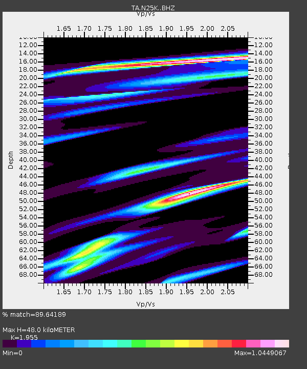
| Estimated Moho Depth: |
48.0 km |
| Estimated Crust Vp/Vs: |
1.96 |
| Assumed Crust Vp: |
6.566 km/s |
| Estimated Crust Vs: |
3.359 km/s |
| Estimated Crust Poisson's Ratio: |
0.32 |
|
| Radial Match: |
89.64189 % |
| Radial Bump: |
400 |
| Transverse Match: |
89.00352 % |
| Transverse Bump: |
400 |
| SOD ConfigId: |
13570011 |
| Insert Time: |
2019-04-29 04:35:09.966 +0000 |
| GWidth: |
2.5 |
| Max Bumps: |
400 |
| Tol: |
0.001 |
|
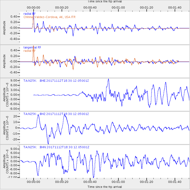
Signal To Noise
| Channel | StoN | STA | LTA |
| TA:N25K: :BHZ:20171112T18:30:12.05001Z | 30.823433 | 1.1477777E-5 | 3.7237177E-7 |
| TA:N25K: :BHN:20171112T18:30:12.05001Z | 7.6356606 | 4.548682E-6 | 5.957156E-7 |
| TA:N25K: :BHE:20171112T18:30:12.05001Z | 5.9222 | 9.4114586E-7 | 1.5891828E-7 |
| Arrivals |
| Ps | 7.2 SECOND |
| PpPs | 21 SECOND |
| PsPs/PpSs | 28 SECOND |


