You are here: Home > Network List > TA - USArray Transportable Network (new EarthScope stations) Stations List
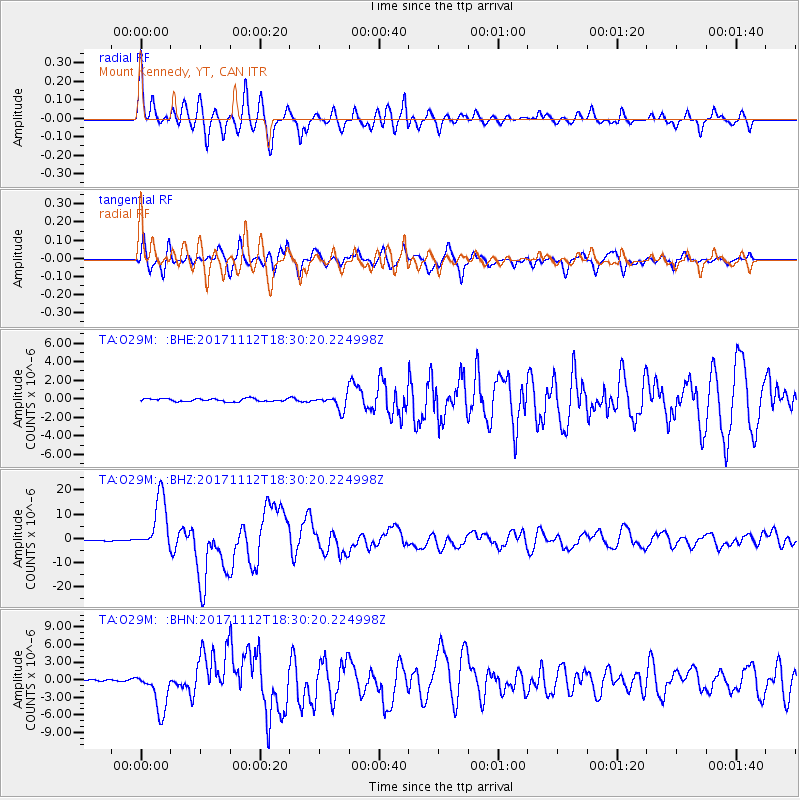
> Station O29M Mount Kennedy, YT, CAN > Earthquake Result Viewer
O29M Mount Kennedy, YT, CAN - Earthquake Result Viewer
| Earthquake location: |
Iran-Iraq Border Region |
| Earthquake latitude/longitude: |
34.9/46.0 |
| Earthquake time(UTC): |
2017/11/12 (316) 18:18:17 GMT |
| Earthquake Depth: |
19 km |
| Earthquake Magnitude: |
7.3 Mww |
| Earthquake Catalog/Contributor: |
NEIC PDE/us |
|
| Network: |
TA USArray Transportable Network (new EarthScope stations) |
| Station: |
O29M Mount Kennedy, YT, CAN |
| Lat/Lon: |
60.30 N/138.58 W |
| Elevation: |
1423 m |
|
| Distance: |
85.1 deg |
| Az: |
2.263 deg |
| Baz: |
356.263 deg |
| Ray Param: |
0.04501649 |
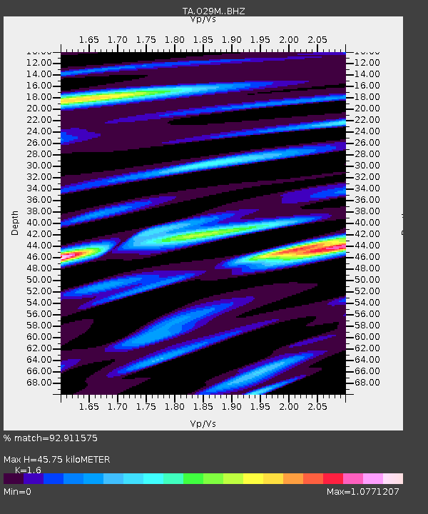
| Estimated Moho Depth: |
45.75 km |
| Estimated Crust Vp/Vs: |
1.60 |
| Assumed Crust Vp: |
6.566 km/s |
| Estimated Crust Vs: |
4.104 km/s |
| Estimated Crust Poisson's Ratio: |
0.18 |
|
| Radial Match: |
92.911575 % |
| Radial Bump: |
400 |
| Transverse Match: |
91.145134 % |
| Transverse Bump: |
400 |
| SOD ConfigId: |
13570011 |
| Insert Time: |
2019-04-29 04:35:20.275 +0000 |
| GWidth: |
2.5 |
| Max Bumps: |
400 |
| Tol: |
0.001 |
|
Signal To Noise
| Channel | StoN | STA | LTA |
| TA:O29M: :BHZ:20171112T18:30:20.224998Z | 34.36144 | 1.1186316E-5 | 3.2554857E-7 |
| TA:O29M: :BHN:20171112T18:30:20.224998Z | 14.72777 | 3.4753327E-6 | 2.3597143E-7 |
| TA:O29M: :BHE:20171112T18:30:20.224998Z | 5.1017885 | 7.71482E-7 | 1.5121795E-7 |
| Arrivals |
| Ps | 4.3 SECOND |
| PpPs | 18 SECOND |
| PsPs/PpSs | 22 SECOND |


