You are here: Home > Network List > TA - USArray Transportable Network (new EarthScope stations) Stations List
> Station P32M Atlin, BC, CAN > Earthquake Result Viewer
P32M Atlin, BC, CAN - Earthquake Result Viewer

| Earthquake location: |
Iran-Iraq Border Region |
| Earthquake latitude/longitude: |
34.9/46.0 |
| Earthquake time(UTC): |
2017/11/12 (316) 18:18:17 GMT |
| Earthquake Depth: |
19 km |
| Earthquake Magnitude: |
7.3 Mww |
| Earthquake Catalog/Contributor: |
NEIC PDE/us |
|
| Network: |
TA USArray Transportable Network (new EarthScope stations) |
| Station: |
P32M Atlin, BC, CAN |
| Lat/Lon: |
59.59 N/133.71 W |
| Elevation: |
793 m |
|
| Distance: |
85.9 deg |
| Az: |
359.832 deg |
| Baz: |
0.271 deg |
| Ray Param: |
0.044451468 |
| Estimated Moho Depth: |
51.25 km |
| Estimated Crust Vp/Vs: |
1.84 |
| Assumed Crust Vp: |
6.597 km/s |
| Estimated Crust Vs: |
3.581 km/s |
| Estimated Crust Poisson's Ratio: |
0.29 |
|
| Radial Match: |
86.262115 % |
| Radial Bump: |
400 |
| Transverse Match: |
67.51651 % |
| Transverse Bump: |
400 |
| SOD ConfigId: |
13570011 |
| Insert Time: |
2019-04-29 04:35:28.851 +0000 |
| GWidth: |
2.5 |
| Max Bumps: |
400 |
| Tol: |
0.001 |
|
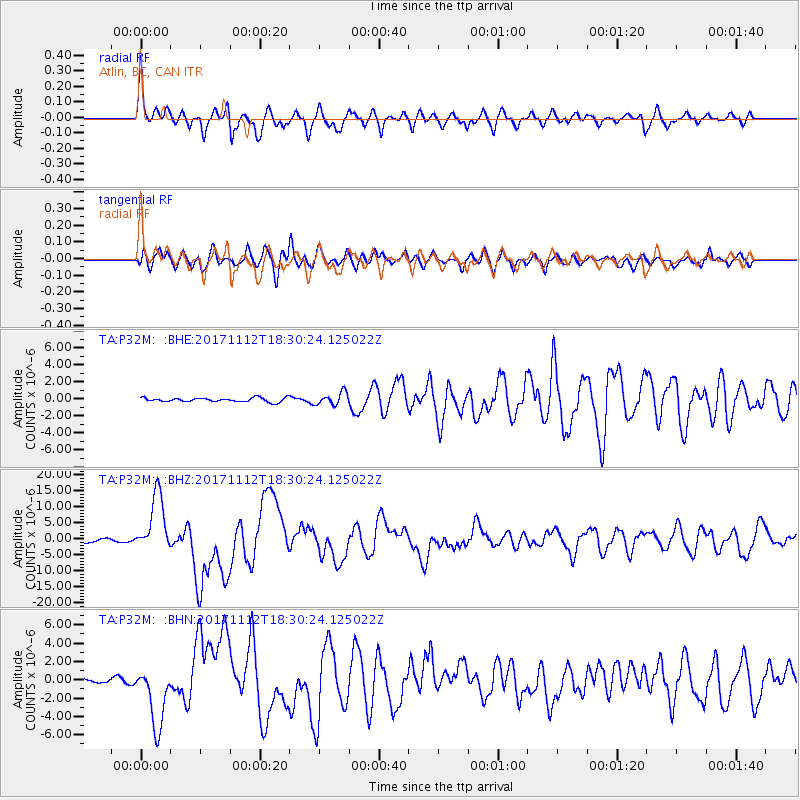
Signal To Noise
| Channel | StoN | STA | LTA |
| TA:P32M: :BHZ:20171112T18:30:24.125022Z | 19.167124 | 9.175521E-6 | 4.787114E-7 |
| TA:P32M: :BHN:20171112T18:30:24.125022Z | 10.989366 | 3.408002E-6 | 3.1011817E-7 |
| TA:P32M: :BHE:20171112T18:30:24.125022Z | 3.1436791 | 7.117833E-7 | 2.264173E-7 |
| Arrivals |
| Ps | 6.7 SECOND |
| PpPs | 22 SECOND |
| PsPs/PpSs | 28 SECOND |


