You are here: Home > Network List > TA - USArray Transportable Network (new EarthScope stations) Stations List
> Station P33M Teslin, Yukon, CA > Earthquake Result Viewer
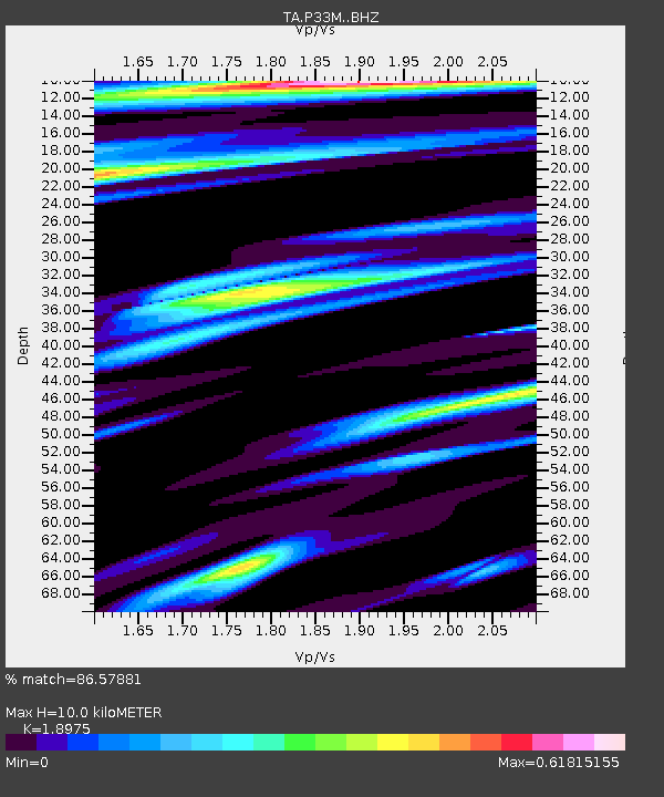
P33M Teslin, Yukon, CA - Earthquake Result Viewer
| Earthquake location: |
Iran-Iraq Border Region |
| Earthquake latitude/longitude: |
34.9/46.0 |
| Earthquake time(UTC): |
2017/11/12 (316) 18:18:17 GMT |
| Earthquake Depth: |
19 km |
| Earthquake Magnitude: |
7.3 Mww |
| Earthquake Catalog/Contributor: |
NEIC PDE/us |
|
| Network: |
TA USArray Transportable Network (new EarthScope stations) |
| Station: |
P33M Teslin, Yukon, CA |
| Lat/Lon: |
60.21 N/132.82 W |
| Elevation: |
1066 m |
|
| Distance: |
85.2 deg |
| Az: |
359.386 deg |
| Baz: |
1.011 deg |
| Ray Param: |
0.04490187 |
| Estimated Moho Depth: |
10.0 km |
| Estimated Crust Vp/Vs: |
1.90 |
| Assumed Crust Vp: |
6.419 km/s |
| Estimated Crust Vs: |
3.383 km/s |
| Estimated Crust Poisson's Ratio: |
0.31 |
|
| Radial Match: |
86.57881 % |
| Radial Bump: |
400 |
| Transverse Match: |
84.67706 % |
| Transverse Bump: |
400 |
| SOD ConfigId: |
13570011 |
| Insert Time: |
2019-04-29 04:35:30.541 +0000 |
| GWidth: |
2.5 |
| Max Bumps: |
400 |
| Tol: |
0.001 |
|

Signal To Noise
| Channel | StoN | STA | LTA |
| TA:P33M: :BHZ:20171112T18:30:21.024985Z | 31.259796 | 1.1947813E-5 | 3.8221017E-7 |
| TA:P33M: :BHN:20171112T18:30:21.024985Z | 11.593226 | 4.667692E-6 | 4.0262233E-7 |
| TA:P33M: :BHE:20171112T18:30:21.024985Z | 1.8001826 | 7.37563E-7 | 4.0971568E-7 |
| Arrivals |
| Ps | 1.4 SECOND |
| PpPs | 4.4 SECOND |
| PsPs/PpSs | 5.8 SECOND |


