You are here: Home > Network List > TA - USArray Transportable Network (new EarthScope stations) Stations List
> Station R17K Ugashik Creek, AK, USA > Earthquake Result Viewer
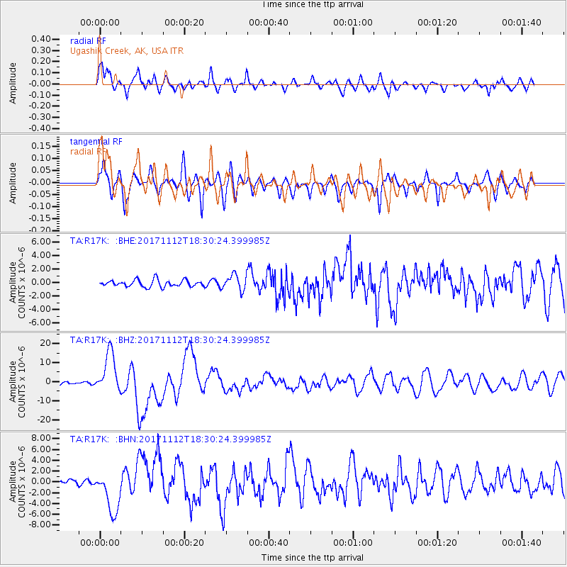
R17K Ugashik Creek, AK, USA - Earthquake Result Viewer
*The percent match for this event was below the threshold and hence no stack was calculated.
| Earthquake location: |
Iran-Iraq Border Region |
| Earthquake latitude/longitude: |
34.9/46.0 |
| Earthquake time(UTC): |
2017/11/12 (316) 18:18:17 GMT |
| Earthquake Depth: |
19 km |
| Earthquake Magnitude: |
7.3 Mww |
| Earthquake Catalog/Contributor: |
NEIC PDE/us |
|
| Network: |
TA USArray Transportable Network (new EarthScope stations) |
| Station: |
R17K Ugashik Creek, AK, USA |
| Lat/Lon: |
57.64 N/156.39 W |
| Elevation: |
273 m |
|
| Distance: |
85.9 deg |
| Az: |
11.828 deg |
| Baz: |
341.745 deg |
| Ray Param: |
$rayparam |
*The percent match for this event was below the threshold and hence was not used in the summary stack. |
|
| Radial Match: |
74.156166 % |
| Radial Bump: |
400 |
| Transverse Match: |
70.66129 % |
| Transverse Bump: |
400 |
| SOD ConfigId: |
13570011 |
| Insert Time: |
2019-04-29 04:35:39.031 +0000 |
| GWidth: |
2.5 |
| Max Bumps: |
400 |
| Tol: |
0.001 |
|
Signal To Noise
| Channel | StoN | STA | LTA |
| TA:R17K: :BHZ:20171112T18:30:24.399985Z | 19.332367 | 1.1025035E-5 | 5.7028893E-7 |
| TA:R17K: :BHN:20171112T18:30:24.399985Z | 8.061025 | 4.110517E-6 | 5.0992486E-7 |
| TA:R17K: :BHE:20171112T18:30:24.399985Z | 2.3627381 | 1.1793713E-6 | 4.991545E-7 |
| Arrivals |
| Ps | |
| PpPs | |
| PsPs/PpSs | |


