You are here: Home > Network List > TA - USArray Transportable Network (new EarthScope stations) Stations List
> Station S34M Telegraph Creek, BC, CAN > Earthquake Result Viewer
S34M Telegraph Creek, BC, CAN - Earthquake Result Viewer
| Earthquake location: |
Iran-Iraq Border Region |
| Earthquake latitude/longitude: |
34.9/46.0 |
| Earthquake time(UTC): |
2017/11/12 (316) 18:18:17 GMT |
| Earthquake Depth: |
19 km |
| Earthquake Magnitude: |
7.3 Mww |
| Earthquake Catalog/Contributor: |
NEIC PDE/us |
|
| Network: |
TA USArray Transportable Network (new EarthScope stations) |
| Station: |
S34M Telegraph Creek, BC, CAN |
| Lat/Lon: |
57.91 N/131.13 W |
| Elevation: |
298 m |
|
| Distance: |
87.5 deg |
| Az: |
358.444 deg |
| Baz: |
2.396 deg |
| Ray Param: |
0.043264885 |
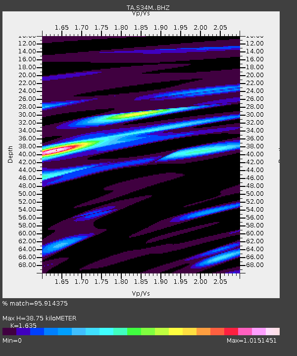
| Estimated Moho Depth: |
38.75 km |
| Estimated Crust Vp/Vs: |
1.63 |
| Assumed Crust Vp: |
6.597 km/s |
| Estimated Crust Vs: |
4.035 km/s |
| Estimated Crust Poisson's Ratio: |
0.20 |
|
| Radial Match: |
95.914375 % |
| Radial Bump: |
400 |
| Transverse Match: |
95.04759 % |
| Transverse Bump: |
400 |
| SOD ConfigId: |
13570011 |
| Insert Time: |
2019-04-29 04:35:45.452 +0000 |
| GWidth: |
2.5 |
| Max Bumps: |
400 |
| Tol: |
0.001 |
|

Signal To Noise
| Channel | StoN | STA | LTA |
| TA:S34M: :BHZ:20171112T18:30:32.17501Z | 30.960857 | 1.3268041E-5 | 4.2854242E-7 |
| TA:S34M: :BHN:20171112T18:30:32.17501Z | 12.597235 | 4.2702063E-6 | 3.3897965E-7 |
| TA:S34M: :BHE:20171112T18:30:32.17501Z | 1.2857306 | 5.014302E-7 | 3.8999627E-7 |
| Arrivals |
| Ps | 3.8 SECOND |
| PpPs | 15 SECOND |
| PsPs/PpSs | 19 SECOND |


