You are here: Home > Network List > TA - USArray Transportable Network (new EarthScope stations) Stations List
> Station T33K Petersburg, AK, USA > Earthquake Result Viewer
T33K Petersburg, AK, USA - Earthquake Result Viewer
| Earthquake location: |
Iran-Iraq Border Region |
| Earthquake latitude/longitude: |
34.9/46.0 |
| Earthquake time(UTC): |
2017/11/12 (316) 18:18:17 GMT |
| Earthquake Depth: |
19 km |
| Earthquake Magnitude: |
7.3 Mww |
| Earthquake Catalog/Contributor: |
NEIC PDE/us |
|
| Network: |
TA USArray Transportable Network (new EarthScope stations) |
| Station: |
T33K Petersburg, AK, USA |
| Lat/Lon: |
56.81 N/132.95 W |
| Elevation: |
22 m |
|
| Distance: |
88.6 deg |
| Az: |
359.4 deg |
| Baz: |
0.897 deg |
| Ray Param: |
0.042426214 |
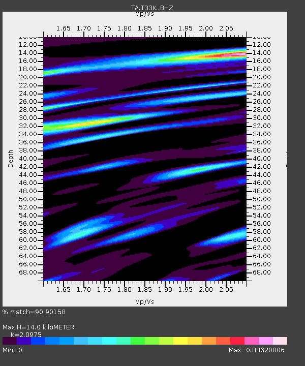
| Estimated Moho Depth: |
14.0 km |
| Estimated Crust Vp/Vs: |
2.10 |
| Assumed Crust Vp: |
6.597 km/s |
| Estimated Crust Vs: |
3.145 km/s |
| Estimated Crust Poisson's Ratio: |
0.35 |
|
| Radial Match: |
90.90158 % |
| Radial Bump: |
400 |
| Transverse Match: |
89.488686 % |
| Transverse Bump: |
400 |
| SOD ConfigId: |
13570011 |
| Insert Time: |
2019-04-29 04:35:48.606 +0000 |
| GWidth: |
2.5 |
| Max Bumps: |
400 |
| Tol: |
0.001 |
|
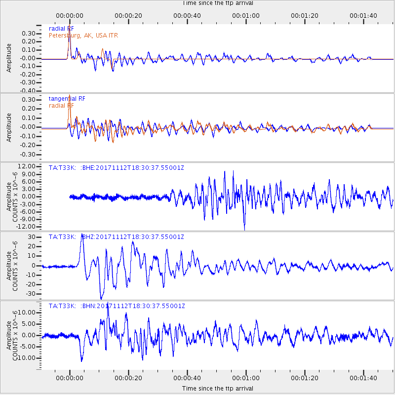
Signal To Noise
| Channel | StoN | STA | LTA |
| TA:T33K: :BHZ:20171112T18:30:37.55001Z | 24.71185 | 1.3534324E-5 | 5.476856E-7 |
| TA:T33K: :BHN:20171112T18:30:37.55001Z | 6.384341 | 4.0722007E-6 | 6.37842E-7 |
| TA:T33K: :BHE:20171112T18:30:37.55001Z | 1.3997456 | 8.2219253E-7 | 5.8738715E-7 |
| Arrivals |
| Ps | 2.4 SECOND |
| PpPs | 6.4 SECOND |
| PsPs/PpSs | 8.8 SECOND |


