You are here: Home > Network List > TA - USArray Transportable Network (new EarthScope stations) Stations List
> Station V35K Ketchikan, AK, USA > Earthquake Result Viewer
V35K Ketchikan, AK, USA - Earthquake Result Viewer
| Earthquake location: |
Iran-Iraq Border Region |
| Earthquake latitude/longitude: |
34.9/46.0 |
| Earthquake time(UTC): |
2017/11/12 (316) 18:18:17 GMT |
| Earthquake Depth: |
19 km |
| Earthquake Magnitude: |
7.3 Mww |
| Earthquake Catalog/Contributor: |
NEIC PDE/us |
|
| Network: |
TA USArray Transportable Network (new EarthScope stations) |
| Station: |
V35K Ketchikan, AK, USA |
| Lat/Lon: |
55.33 N/131.62 W |
| Elevation: |
64 m |
|
| Distance: |
90.1 deg |
| Az: |
358.612 deg |
| Baz: |
1.996 deg |
| Ray Param: |
0.041695796 |
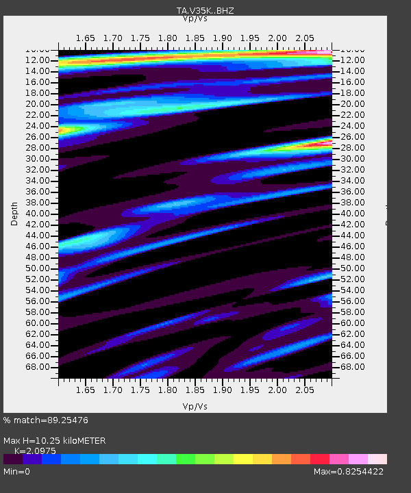
| Estimated Moho Depth: |
10.25 km |
| Estimated Crust Vp/Vs: |
2.10 |
| Assumed Crust Vp: |
6.545 km/s |
| Estimated Crust Vs: |
3.121 km/s |
| Estimated Crust Poisson's Ratio: |
0.35 |
|
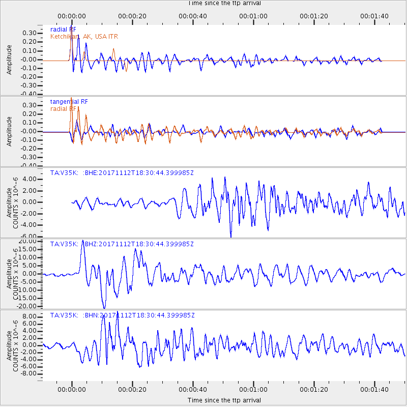
| Radial Match: |
89.25476 % |
| Radial Bump: |
400 |
| Transverse Match: |
72.85044 % |
| Transverse Bump: |
400 |
| SOD ConfigId: |
13570011 |
| Insert Time: |
2019-04-29 04:35:51.033 +0000 |
| GWidth: |
2.5 |
| Max Bumps: |
400 |
| Tol: |
0.001 |
|
Signal To Noise
| Channel | StoN | STA | LTA |
| TA:V35K: :BHZ:20171112T18:30:44.399985Z | 17.307716 | 8.840139E-6 | 5.107629E-7 |
| TA:V35K: :BHN:20171112T18:30:44.399985Z | 5.154165 | 2.1421315E-6 | 4.1561177E-7 |
| TA:V35K: :BHE:20171112T18:30:44.399985Z | 1.1168749 | 5.54112E-7 | 4.9612714E-7 |
| Arrivals |
| Ps | 1.8 SECOND |
| PpPs | 4.8 SECOND |
| PsPs/PpSs | 6.5 SECOND |


