You are here: Home > Network List > TA - USArray Transportable Network (new EarthScope stations) Stations List
> Station M18A Lyman, WY, USA > Earthquake Result Viewer
M18A Lyman, WY, USA - Earthquake Result Viewer
*The percent match for this event was below the threshold and hence no stack was calculated.
| Earthquake location: |
Guatemala |
| Earthquake latitude/longitude: |
14.6/-91.2 |
| Earthquake time(UTC): |
2009/05/03 (123) 16:21:47 GMT |
| Earthquake Depth: |
124 km |
| Earthquake Magnitude: |
5.6 MB, 6.2 MW, 6.2 MW |
| Earthquake Catalog/Contributor: |
WHDF/NEIC |
|
| Network: |
TA USArray Transportable Network (new EarthScope stations) |
| Station: |
M18A Lyman, WY, USA |
| Lat/Lon: |
41.43 N/110.07 W |
| Elevation: |
2103 m |
|
| Distance: |
31.4 deg |
| Az: |
332.118 deg |
| Baz: |
142.978 deg |
| Ray Param: |
$rayparam |
*The percent match for this event was below the threshold and hence was not used in the summary stack. |
|
| Radial Match: |
68.76509 % |
| Radial Bump: |
400 |
| Transverse Match: |
58.739433 % |
| Transverse Bump: |
382 |
| SOD ConfigId: |
2658 |
| Insert Time: |
2010-03-06 06:18:07.558 +0000 |
| GWidth: |
2.5 |
| Max Bumps: |
400 |
| Tol: |
0.001 |
|
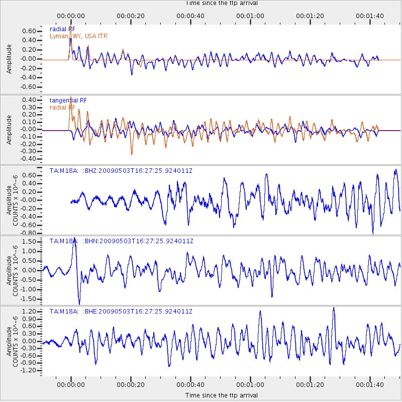
Signal To Noise
| Channel | StoN | STA | LTA |
| TA:M18A: :BHN:20090503T16:27:25.924011Z | 6.613148 | 9.3813554E-7 | 1.4185915E-7 |
| TA:M18A: :BHE:20090503T16:27:25.924011Z | 2.2096102 | 2.2684846E-7 | 1.02664465E-7 |
| TA:M18A: :BHZ:20090503T16:27:25.924011Z | 2.7561257 | 2.7939876E-7 | 1.0137375E-7 |
| Arrivals |
| Ps | |
| PpPs | |
| PsPs/PpSs | |


