You are here: Home > Network List > UM - University of Montana - Missoula Stations List
> Station LGMT Long Gulch > Earthquake Result Viewer
LGMT Long Gulch - Earthquake Result Viewer
| Earthquake location: |
Iran-Iraq Border Region |
| Earthquake latitude/longitude: |
34.9/46.0 |
| Earthquake time(UTC): |
2017/11/12 (316) 18:18:17 GMT |
| Earthquake Depth: |
19 km |
| Earthquake Magnitude: |
7.3 Mww |
| Earthquake Catalog/Contributor: |
NEIC PDE/us |
|
| Network: |
UM University of Montana - Missoula |
| Station: |
LGMT Long Gulch |
| Lat/Lon: |
46.88 N/112.61 W |
| Elevation: |
1784 m |
|
| Distance: |
96.3 deg |
| Az: |
345.389 deg |
| Baz: |
17.593 deg |
| Ray Param: |
0.040539794 |
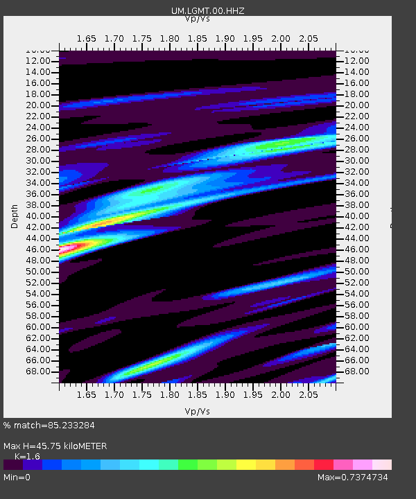
| Estimated Moho Depth: |
45.75 km |
| Estimated Crust Vp/Vs: |
1.60 |
| Assumed Crust Vp: |
6.353 km/s |
| Estimated Crust Vs: |
3.971 km/s |
| Estimated Crust Poisson's Ratio: |
0.18 |
|
| Radial Match: |
85.233284 % |
| Radial Bump: |
400 |
| Transverse Match: |
75.078545 % |
| Transverse Bump: |
400 |
| SOD ConfigId: |
13570011 |
| Insert Time: |
2019-04-29 04:36:10.482 +0000 |
| GWidth: |
2.5 |
| Max Bumps: |
400 |
| Tol: |
0.001 |
|

Signal To Noise
| Channel | StoN | STA | LTA |
| UM:LGMT:00:HHZ:20171112T18:31:12.899985Z | 19.361212 | 3.6999486E-6 | 1.9110108E-7 |
| UM:LGMT:00:HHN:20171112T18:31:12.899985Z | 2.9616883 | 1.3636699E-6 | 4.6043667E-7 |
| UM:LGMT:00:HHE:20171112T18:31:12.899985Z | 1.4409883 | 8.2576236E-7 | 5.730528E-7 |
| Arrivals |
| Ps | 4.4 SECOND |
| PpPs | 18 SECOND |
| PsPs/PpSs | 23 SECOND |


