You are here: Home > Network List > UW - Pacific Northwest Regional Seismic Network Stations List
> Station OMAK Colville Reservation, Omak, WA, USA > Earthquake Result Viewer
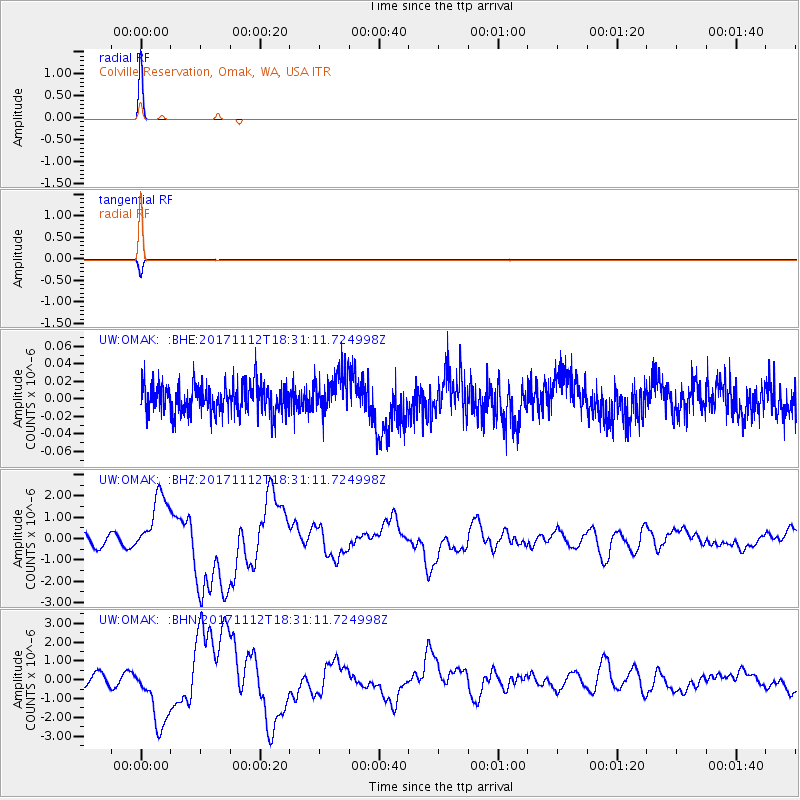
OMAK Colville Reservation, Omak, WA, USA - Earthquake Result Viewer
| Earthquake location: |
Iran-Iraq Border Region |
| Earthquake latitude/longitude: |
34.9/46.0 |
| Earthquake time(UTC): |
2017/11/12 (316) 18:18:17 GMT |
| Earthquake Depth: |
19 km |
| Earthquake Magnitude: |
7.3 Mww |
| Earthquake Catalog/Contributor: |
NEIC PDE/us |
|
| Network: |
UW Pacific Northwest Regional Seismic Network |
| Station: |
OMAK Colville Reservation, Omak, WA, USA |
| Lat/Lon: |
48.36 N/119.33 W |
| Elevation: |
696 m |
|
| Distance: |
96.1 deg |
| Az: |
350.194 deg |
| Baz: |
12.116 deg |
| Ray Param: |
0.040608842 |
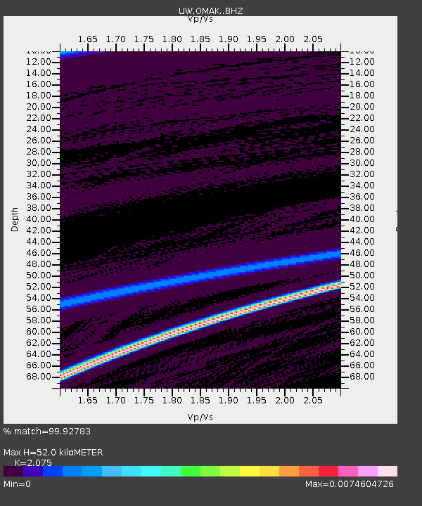
| Estimated Moho Depth: |
52.0 km |
| Estimated Crust Vp/Vs: |
2.08 |
| Assumed Crust Vp: |
6.419 km/s |
| Estimated Crust Vs: |
3.094 km/s |
| Estimated Crust Poisson's Ratio: |
0.35 |
|
| Radial Match: |
99.92783 % |
| Radial Bump: |
6 |
| Transverse Match: |
99.89739 % |
| Transverse Bump: |
13 |
| SOD ConfigId: |
13570011 |
| Insert Time: |
2019-04-29 04:36:23.993 +0000 |
| GWidth: |
2.5 |
| Max Bumps: |
400 |
| Tol: |
0.001 |
|
Signal To Noise
| Channel | StoN | STA | LTA |
| UW:OMAK: :BHZ:20171112T18:31:11.724998Z | 6.0106277 | 1.4763707E-6 | 2.456267E-7 |
| UW:OMAK: :BHN:20171112T18:31:11.724998Z | 5.9377117 | 1.7261203E-6 | 2.9070466E-7 |
| UW:OMAK: :BHE:20171112T18:31:11.724998Z | 1.4316415 | 2.4001343E-8 | 1.6764913E-8 |
| Arrivals |
| Ps | 8.9 SECOND |
| PpPs | 24 SECOND |
| PsPs/PpSs | 33 SECOND |


