You are here: Home > Network List > UW - Pacific Northwest Regional Seismic Network Stations List
> Station MOX Moxee City, WA, USA (was ISC code MXC) > Earthquake Result Viewer
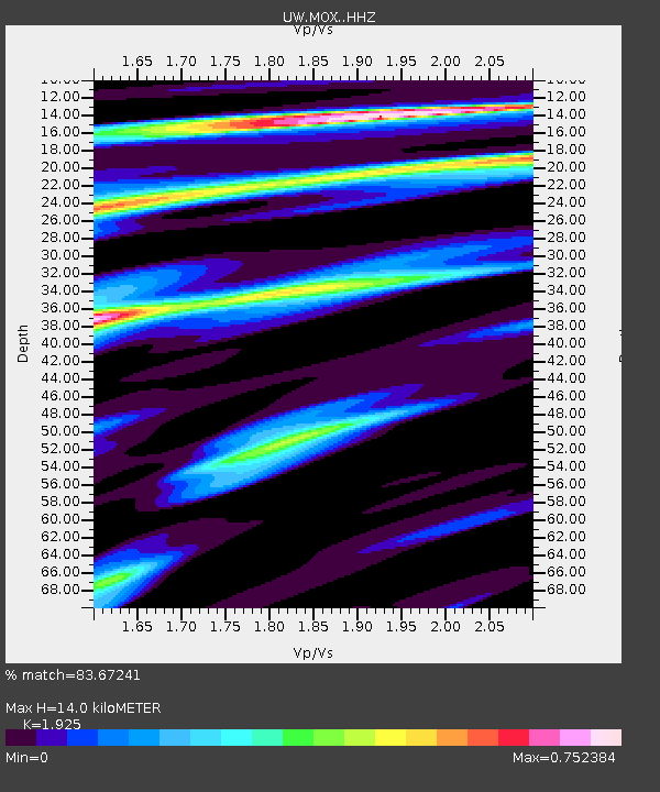
MOX Moxee City, WA, USA (was ISC code MXC) - Earthquake Result Viewer
| Earthquake location: |
Iran-Iraq Border Region |
| Earthquake latitude/longitude: |
34.9/46.0 |
| Earthquake time(UTC): |
2017/11/12 (316) 18:18:17 GMT |
| Earthquake Depth: |
19 km |
| Earthquake Magnitude: |
7.3 Mww |
| Earthquake Catalog/Contributor: |
NEIC PDE/us |
|
| Network: |
UW Pacific Northwest Regional Seismic Network |
| Station: |
MOX Moxee City, WA, USA (was ISC code MXC) |
| Lat/Lon: |
46.58 N/120.30 W |
| Elevation: |
501 m |
|
| Distance: |
97.9 deg |
| Az: |
350.475 deg |
| Baz: |
11.372 deg |
| Ray Param: |
0.040050484 |
| Estimated Moho Depth: |
14.0 km |
| Estimated Crust Vp/Vs: |
1.92 |
| Assumed Crust Vp: |
6.597 km/s |
| Estimated Crust Vs: |
3.427 km/s |
| Estimated Crust Poisson's Ratio: |
0.32 |
|
| Radial Match: |
83.67241 % |
| Radial Bump: |
376 |
| Transverse Match: |
71.93126 % |
| Transverse Bump: |
400 |
| SOD ConfigId: |
13570011 |
| Insert Time: |
2019-04-29 04:36:25.964 +0000 |
| GWidth: |
2.5 |
| Max Bumps: |
400 |
| Tol: |
0.001 |
|

Signal To Noise
| Channel | StoN | STA | LTA |
| UW:MOX: :HHZ:20171112T18:31:20.130027Z | 5.717691 | 3.4401344E-6 | 6.0166496E-7 |
| UW:MOX: :HHN:20171112T18:31:20.130027Z | 2.629489 | 6.930847E-7 | 2.635815E-7 |
| UW:MOX: :HHE:20171112T18:31:20.130027Z | 1.2427566 | 3.5026085E-7 | 2.8184186E-7 |
| Arrivals |
| Ps | 2.0 SECOND |
| PpPs | 6.1 SECOND |
| PsPs/PpSs | 8.1 SECOND |


