You are here: Home > Network List > UW - Pacific Northwest Regional Seismic Network Stations List
> Station MRBL Marblemount, WA, USA > Earthquake Result Viewer
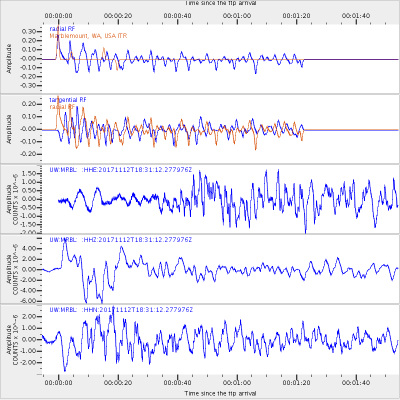
MRBL Marblemount, WA, USA - Earthquake Result Viewer
*The percent match for this event was below the threshold and hence no stack was calculated.
| Earthquake location: |
Iran-Iraq Border Region |
| Earthquake latitude/longitude: |
34.9/46.0 |
| Earthquake time(UTC): |
2017/11/12 (316) 18:18:17 GMT |
| Earthquake Depth: |
19 km |
| Earthquake Magnitude: |
7.3 Mww |
| Earthquake Catalog/Contributor: |
NEIC PDE/us |
|
| Network: |
UW Pacific Northwest Regional Seismic Network |
| Station: |
MRBL Marblemount, WA, USA |
| Lat/Lon: |
48.52 N/121.48 W |
| Elevation: |
75 m |
|
| Distance: |
96.2 deg |
| Az: |
351.638 deg |
| Baz: |
10.356 deg |
| Ray Param: |
$rayparam |
*The percent match for this event was below the threshold and hence was not used in the summary stack. |
|
| Radial Match: |
77.51277 % |
| Radial Bump: |
400 |
| Transverse Match: |
67.929306 % |
| Transverse Bump: |
400 |
| SOD ConfigId: |
13570011 |
| Insert Time: |
2019-04-29 04:36:27.161 +0000 |
| GWidth: |
2.5 |
| Max Bumps: |
400 |
| Tol: |
0.001 |
|
Signal To Noise
| Channel | StoN | STA | LTA |
| UW:MRBL: :HHZ:20171112T18:31:12.277976Z | 7.289934 | 2.8863237E-6 | 3.9593274E-7 |
| UW:MRBL: :HHN:20171112T18:31:12.277976Z | 3.754005 | 1.2690928E-6 | 3.380637E-7 |
| UW:MRBL: :HHE:20171112T18:31:12.277976Z | 0.92956406 | 2.8740368E-7 | 3.0918116E-7 |
| Arrivals |
| Ps | |
| PpPs | |
| PsPs/PpSs | |


