You are here: Home > Network List > TA - USArray Transportable Network (new EarthScope stations) Stations List
> Station M18A Lyman, WY, USA > Earthquake Result Viewer
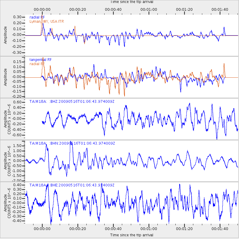
M18A Lyman, WY, USA - Earthquake Result Viewer
*The percent match for this event was below the threshold and hence no stack was calculated.
| Earthquake location: |
Kermadec Islands Region |
| Earthquake latitude/longitude: |
-31.5/-178.8 |
| Earthquake time(UTC): |
2009/05/16 (136) 00:53:52 GMT |
| Earthquake Depth: |
55 km |
| Earthquake Magnitude: |
6.1 MB, 6.5 MW, 6.3 MW |
| Earthquake Catalog/Contributor: |
WHDF/NEIC |
|
| Network: |
TA USArray Transportable Network (new EarthScope stations) |
| Station: |
M18A Lyman, WY, USA |
| Lat/Lon: |
41.43 N/110.07 W |
| Elevation: |
2103 m |
|
| Distance: |
96.3 deg |
| Az: |
44.831 deg |
| Baz: |
233.194 deg |
| Ray Param: |
$rayparam |
*The percent match for this event was below the threshold and hence was not used in the summary stack. |
|
| Radial Match: |
66.0641 % |
| Radial Bump: |
400 |
| Transverse Match: |
73.198715 % |
| Transverse Bump: |
400 |
| SOD ConfigId: |
2760 |
| Insert Time: |
2010-03-06 06:18:30.203 +0000 |
| GWidth: |
2.5 |
| Max Bumps: |
400 |
| Tol: |
0.001 |
|
Signal To Noise
| Channel | StoN | STA | LTA |
| TA:M18A: :BHN:20090516T01:06:43.974009Z | 5.755235 | 8.7979424E-7 | 1.5286851E-7 |
| TA:M18A: :BHE:20090516T01:06:43.974009Z | 0.93410087 | 2.2533546E-7 | 2.4123247E-7 |
| TA:M18A: :BHZ:20090516T01:06:43.974009Z | 1.3607005 | 2.00304E-7 | 1.4720653E-7 |
| Arrivals |
| Ps | |
| PpPs | |
| PsPs/PpSs | |


