You are here: Home > Network List > GS - US Geological Survey Networks Stations List
> Station OK039 N2440 and E0440 Rds, Cleo Springs, OK, USA > Earthquake Result Viewer
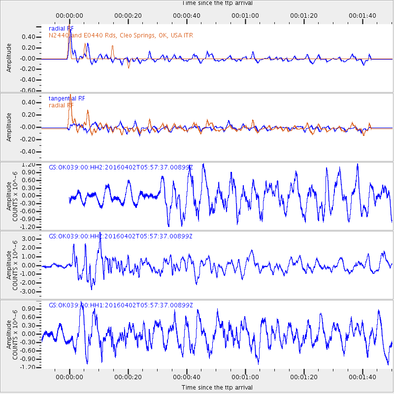
OK039 N2440 and E0440 Rds, Cleo Springs, OK, USA - Earthquake Result Viewer

| Earthquake location: |
Alaska Peninsula |
| Earthquake latitude/longitude: |
57.0/-158.0 |
| Earthquake time(UTC): |
2016/04/02 (093) 05:50:00 GMT |
| Earthquake Depth: |
10 km |
| Earthquake Magnitude: |
6.2 MWP, 6.4 MI |
| Earthquake Catalog/Contributor: |
NEIC PDE/NEIC COMCAT |
|
| Network: |
GS US Geological Survey Networks |
| Station: |
OK039 N2440 and E0440 Rds, Cleo Springs, OK, USA |
| Lat/Lon: |
36.38 N/98.65 W |
| Elevation: |
400 m |
|
| Distance: |
44.0 deg |
| Az: |
91.831 deg |
| Baz: |
317.391 deg |
| Ray Param: |
0.07220741 |
| Estimated Moho Depth: |
16.25 km |
| Estimated Crust Vp/Vs: |
1.65 |
| Assumed Crust Vp: |
6.426 km/s |
| Estimated Crust Vs: |
3.889 km/s |
| Estimated Crust Poisson's Ratio: |
0.21 |
|
| Radial Match: |
84.16878 % |
| Radial Bump: |
400 |
| Transverse Match: |
75.85069 % |
| Transverse Bump: |
400 |
| SOD ConfigId: |
1475611 |
| Insert Time: |
2016-04-16 06:03:09.301 +0000 |
| GWidth: |
2.5 |
| Max Bumps: |
400 |
| Tol: |
0.001 |
|
Signal To Noise
| Channel | StoN | STA | LTA |
| GS:OK039:00:HHZ:20160402T05:57:37.00899Z | 5.4595723 | 9.961888E-7 | 1.8246644E-7 |
| GS:OK039:00:HH1:20160402T05:57:37.00899Z | 4.0681853 | 5.5290394E-7 | 1.3590923E-7 |
| GS:OK039:00:HH2:20160402T05:57:37.00899Z | 2.271969 | 5.2581885E-7 | 2.314375E-7 |
| Arrivals |
| Ps | 1.8 SECOND |
| PpPs | 6.3 SECOND |
| PsPs/PpSs | 8.0 SECOND |


