You are here: Home > Network List > TA - USArray Transportable Network (new EarthScope stations) Stations List
> Station M18A Lyman, WY, USA > Earthquake Result Viewer
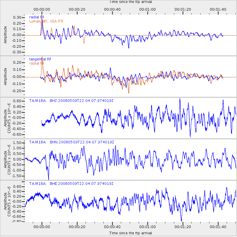
M18A Lyman, WY, USA - Earthquake Result Viewer
*The percent match for this event was below the threshold and hence no stack was calculated.
| Earthquake location: |
South Of Mariana Islands |
| Earthquake latitude/longitude: |
12.5/143.2 |
| Earthquake time(UTC): |
2008/05/09 (130) 21:51:29 GMT |
| Earthquake Depth: |
76 km |
| Earthquake Magnitude: |
6.1 MB, 6.7 MW, 6.7 MW |
| Earthquake Catalog/Contributor: |
WHDF/NEIC |
|
| Network: |
TA USArray Transportable Network (new EarthScope stations) |
| Station: |
M18A Lyman, WY, USA |
| Lat/Lon: |
41.43 N/110.07 W |
| Elevation: |
2103 m |
|
| Distance: |
94.0 deg |
| Az: |
46.207 deg |
| Baz: |
290.384 deg |
| Ray Param: |
$rayparam |
*The percent match for this event was below the threshold and hence was not used in the summary stack. |
|
| Radial Match: |
65.970665 % |
| Radial Bump: |
400 |
| Transverse Match: |
47.90255 % |
| Transverse Bump: |
400 |
| SOD ConfigId: |
2504 |
| Insert Time: |
2010-03-06 06:18:56.609 +0000 |
| GWidth: |
2.5 |
| Max Bumps: |
400 |
| Tol: |
0.001 |
|
Signal To Noise
| Channel | StoN | STA | LTA |
| TA:M18A: :BHN:20080509T22:04:07.974019Z | 3.8239827 | 5.945483E-7 | 1.5547882E-7 |
| TA:M18A: :BHE:20080509T22:04:07.974019Z | 1.7628144 | 2.6632378E-7 | 1.5107874E-7 |
| TA:M18A: :BHZ:20080509T22:04:07.974019Z | 1.7899659 | 2.302136E-7 | 1.286134E-7 |
| Arrivals |
| Ps | |
| PpPs | |
| PsPs/PpSs | |


