You are here: Home > Network List > GS - US Geological Survey Networks Stations List
> Station OK043 N2390 and E0400 Rds, Waynoka, OK, USA > Earthquake Result Viewer
OK043 N2390 and E0400 Rds, Waynoka, OK, USA - Earthquake Result Viewer
| Earthquake location: |
Alaska Peninsula |
| Earthquake latitude/longitude: |
57.0/-158.0 |
| Earthquake time(UTC): |
2016/04/02 (093) 05:50:00 GMT |
| Earthquake Depth: |
10 km |
| Earthquake Magnitude: |
6.2 MWP, 6.4 MI |
| Earthquake Catalog/Contributor: |
NEIC PDE/NEIC COMCAT |
|
| Network: |
GS US Geological Survey Networks |
| Station: |
OK043 N2390 and E0400 Rds, Waynoka, OK, USA |
| Lat/Lon: |
36.43 N/98.75 W |
| Elevation: |
406 m |
|
| Distance: |
43.9 deg |
| Az: |
91.861 deg |
| Baz: |
317.358 deg |
| Ray Param: |
0.072265826 |
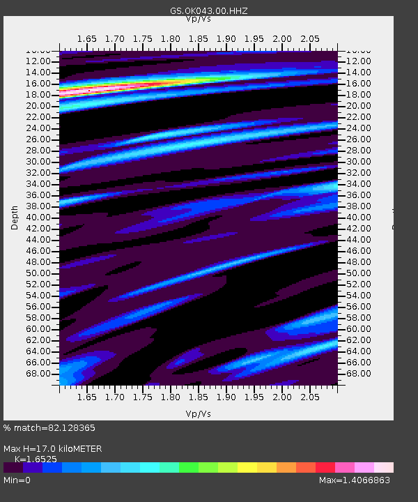
| Estimated Moho Depth: |
17.0 km |
| Estimated Crust Vp/Vs: |
1.65 |
| Assumed Crust Vp: |
6.426 km/s |
| Estimated Crust Vs: |
3.889 km/s |
| Estimated Crust Poisson's Ratio: |
0.21 |
|
| Radial Match: |
82.128365 % |
| Radial Bump: |
350 |
| Transverse Match: |
77.657936 % |
| Transverse Bump: |
400 |
| SOD ConfigId: |
1475611 |
| Insert Time: |
2016-04-16 06:04:31.706 +0000 |
| GWidth: |
2.5 |
| Max Bumps: |
400 |
| Tol: |
0.001 |
|

Signal To Noise
| Channel | StoN | STA | LTA |
| GS:OK043:00:HHZ:20160402T05:57:36.298999Z | 5.6008167 | 1.1488053E-6 | 2.0511389E-7 |
| GS:OK043:00:HH1:20160402T05:57:36.298999Z | 1.9734997 | 4.5459947E-7 | 2.3035193E-7 |
| GS:OK043:00:HH2:20160402T05:57:36.298999Z | 1.7862549 | 4.8003756E-7 | 2.6873965E-7 |
| Arrivals |
| Ps | 1.9 SECOND |
| PpPs | 6.5 SECOND |
| PsPs/PpSs | 8.4 SECOND |


