You are here: Home > Network List > TA - USArray Transportable Network (new EarthScope stations) Stations List
> Station M18A Lyman, WY, USA > Earthquake Result Viewer
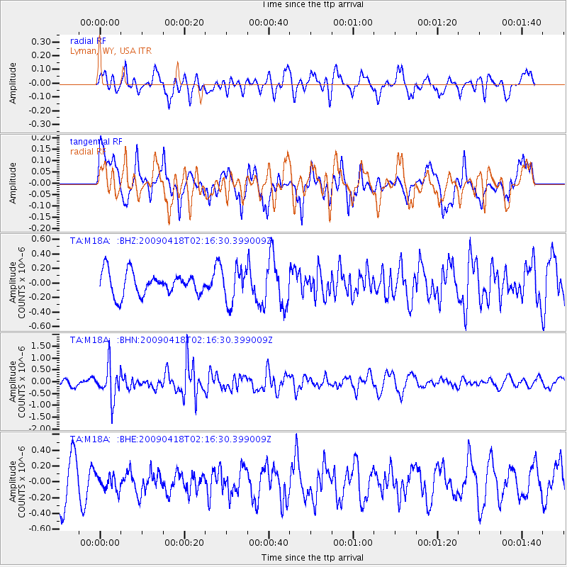
M18A Lyman, WY, USA - Earthquake Result Viewer
*The percent match for this event was below the threshold and hence no stack was calculated.
| Earthquake location: |
Kermadec Islands Region |
| Earthquake latitude/longitude: |
-28.9/-177.4 |
| Earthquake time(UTC): |
2009/04/18 (108) 02:03:52 GMT |
| Earthquake Depth: |
65 km |
| Earthquake Magnitude: |
6.0 MB, 5.8 MW, 5.7 MW |
| Earthquake Catalog/Contributor: |
WHDF/NEIC |
|
| Network: |
TA USArray Transportable Network (new EarthScope stations) |
| Station: |
M18A Lyman, WY, USA |
| Lat/Lon: |
41.43 N/110.07 W |
| Elevation: |
2103 m |
|
| Distance: |
93.6 deg |
| Az: |
44.07 deg |
| Baz: |
234.183 deg |
| Ray Param: |
$rayparam |
*The percent match for this event was below the threshold and hence was not used in the summary stack. |
|
| Radial Match: |
60.934822 % |
| Radial Bump: |
400 |
| Transverse Match: |
53.50912 % |
| Transverse Bump: |
400 |
| SOD ConfigId: |
2658 |
| Insert Time: |
2010-03-06 06:19:26.863 +0000 |
| GWidth: |
2.5 |
| Max Bumps: |
400 |
| Tol: |
0.001 |
|
Signal To Noise
| Channel | StoN | STA | LTA |
| TA:M18A: :BHN:20090418T02:16:30.399009Z | 3.696754 | 7.1093933E-7 | 1.9231449E-7 |
| TA:M18A: :BHE:20090418T02:16:30.399009Z | 0.3170973 | 9.490088E-8 | 2.9927998E-7 |
| TA:M18A: :BHZ:20090418T02:16:30.399009Z | 1.5013467 | 2.3294434E-7 | 1.5515693E-7 |
| Arrivals |
| Ps | |
| PpPs | |
| PsPs/PpSs | |


