You are here: Home > Network List > IU - Global Seismograph Network (GSN - IRIS/USGS) Stations List
> Station PMG Port Moresby, New Guinea > Earthquake Result Viewer
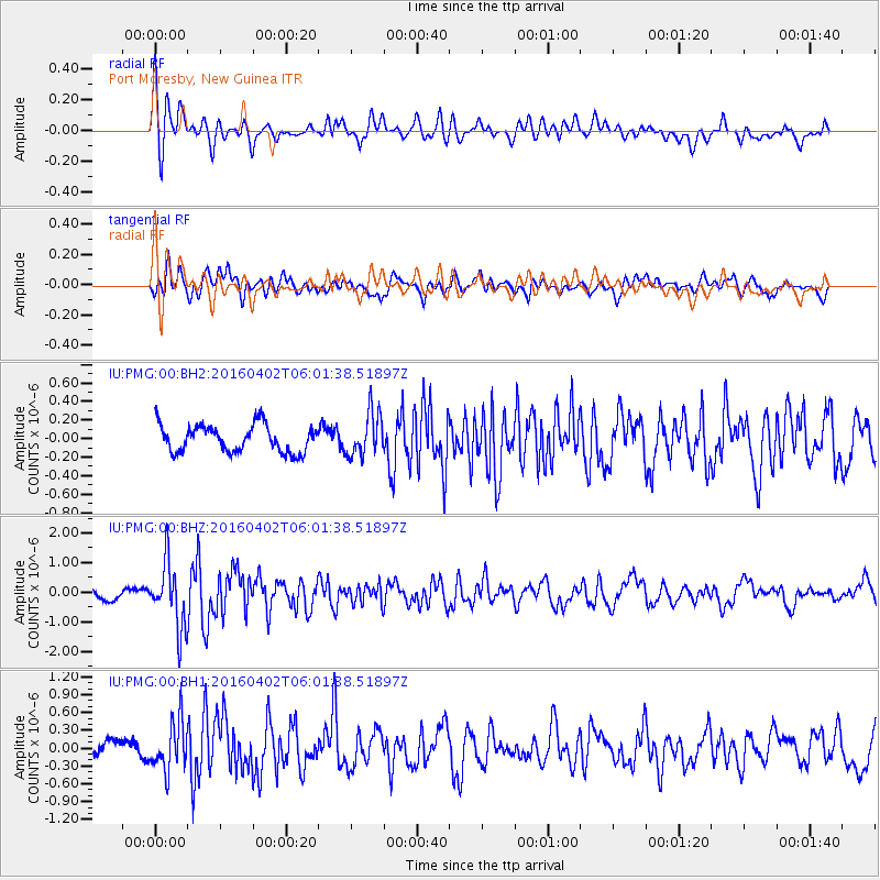
PMG Port Moresby, New Guinea - Earthquake Result Viewer
*The percent match for this event was below the threshold and hence no stack was calculated.
| Earthquake location: |
Alaska Peninsula |
| Earthquake latitude/longitude: |
57.0/-158.0 |
| Earthquake time(UTC): |
2016/04/02 (093) 05:50:00 GMT |
| Earthquake Depth: |
10 km |
| Earthquake Magnitude: |
6.2 MWP, 6.4 MI |
| Earthquake Catalog/Contributor: |
NEIC PDE/NEIC COMCAT |
|
| Network: |
IU Global Seismograph Network (GSN - IRIS/USGS) |
| Station: |
PMG Port Moresby, New Guinea |
| Lat/Lon: |
9.40 S/147.16 E |
| Elevation: |
90 m |
|
| Distance: |
80.0 deg |
| Az: |
235.056 deg |
| Baz: |
27.005 deg |
| Ray Param: |
$rayparam |
*The percent match for this event was below the threshold and hence was not used in the summary stack. |
|
| Radial Match: |
66.264114 % |
| Radial Bump: |
400 |
| Transverse Match: |
79.408295 % |
| Transverse Bump: |
400 |
| SOD ConfigId: |
1475611 |
| Insert Time: |
2016-04-16 06:12:24.673 +0000 |
| GWidth: |
2.5 |
| Max Bumps: |
400 |
| Tol: |
0.001 |
|
Signal To Noise
| Channel | StoN | STA | LTA |
| IU:PMG:00:BHZ:20160402T06:01:38.51897Z | 6.2794895 | 1.07601E-6 | 1.7135311E-7 |
| IU:PMG:00:BH1:20160402T06:01:38.51897Z | 2.0254264 | 4.0231504E-7 | 1.9863228E-7 |
| IU:PMG:00:BH2:20160402T06:01:38.51897Z | 1.612209 | 2.3375509E-7 | 1.4499058E-7 |
| Arrivals |
| Ps | |
| PpPs | |
| PsPs/PpSs | |


