You are here: Home > Network List > CI - Caltech Regional Seismic Network Stations List
> Station MPP McPhearson Peak > Earthquake Result Viewer
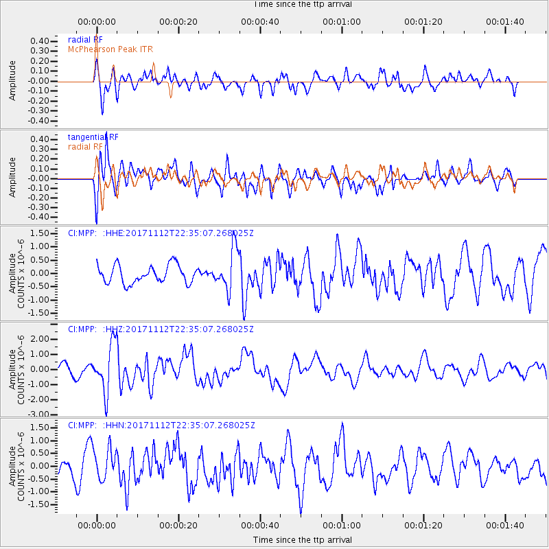
MPP McPhearson Peak - Earthquake Result Viewer
*The percent match for this event was below the threshold and hence no stack was calculated.
| Earthquake location: |
Off East Coast Of Honshu, Japan |
| Earthquake latitude/longitude: |
38.1/144.9 |
| Earthquake time(UTC): |
2017/11/12 (316) 22:24:07 GMT |
| Earthquake Depth: |
9.5 km |
| Earthquake Magnitude: |
5.8 Mww |
| Earthquake Catalog/Contributor: |
NEIC PDE/us |
|
| Network: |
CI Caltech Regional Seismic Network |
| Station: |
MPP McPhearson Peak |
| Lat/Lon: |
34.89 N/119.81 W |
| Elevation: |
1739 m |
|
| Distance: |
73.2 deg |
| Az: |
58.782 deg |
| Baz: |
304.79 deg |
| Ray Param: |
$rayparam |
*The percent match for this event was below the threshold and hence was not used in the summary stack. |
|
| Radial Match: |
65.45434 % |
| Radial Bump: |
400 |
| Transverse Match: |
68.801956 % |
| Transverse Bump: |
400 |
| SOD ConfigId: |
13570011 |
| Insert Time: |
2019-04-29 04:41:04.449 +0000 |
| GWidth: |
2.5 |
| Max Bumps: |
400 |
| Tol: |
0.001 |
|
Signal To Noise
| Channel | StoN | STA | LTA |
| CI:MPP: :HHZ:20171112T22:35:07.268025Z | 5.3598437 | 1.6521892E-6 | 3.0825325E-7 |
| CI:MPP: :HHN:20171112T22:35:07.268025Z | 1.2768178 | 6.2540323E-7 | 4.89814E-7 |
| CI:MPP: :HHE:20171112T22:35:07.268025Z | 2.430908 | 8.124933E-7 | 3.342345E-7 |
| Arrivals |
| Ps | |
| PpPs | |
| PsPs/PpSs | |


