You are here: Home > Network List > CN - Canadian National Seismograph Network Stations List
> Station INK INUVIK, NT > Earthquake Result Viewer
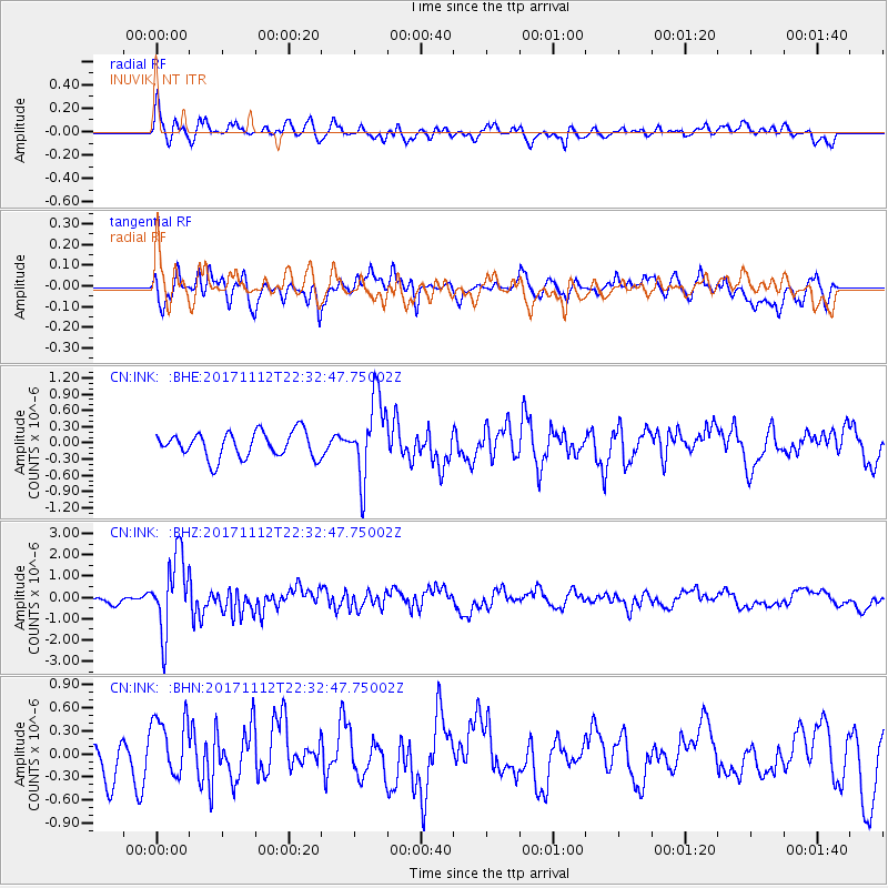
INK INUVIK, NT - Earthquake Result Viewer
*The percent match for this event was below the threshold and hence no stack was calculated.
| Earthquake location: |
Off East Coast Of Honshu, Japan |
| Earthquake latitude/longitude: |
38.1/144.9 |
| Earthquake time(UTC): |
2017/11/12 (316) 22:24:07 GMT |
| Earthquake Depth: |
9.5 km |
| Earthquake Magnitude: |
5.8 Mww |
| Earthquake Catalog/Contributor: |
NEIC PDE/us |
|
| Network: |
CN Canadian National Seismograph Network |
| Station: |
INK INUVIK, NT |
| Lat/Lon: |
68.31 N/133.53 W |
| Elevation: |
44 m |
|
| Distance: |
52.2 deg |
| Az: |
27.737 deg |
| Baz: |
278.806 deg |
| Ray Param: |
$rayparam |
*The percent match for this event was below the threshold and hence was not used in the summary stack. |
|
| Radial Match: |
63.761898 % |
| Radial Bump: |
400 |
| Transverse Match: |
59.9211 % |
| Transverse Bump: |
400 |
| SOD ConfigId: |
13570011 |
| Insert Time: |
2019-04-29 04:41:38.002 +0000 |
| GWidth: |
2.5 |
| Max Bumps: |
400 |
| Tol: |
0.001 |
|
Signal To Noise
| Channel | StoN | STA | LTA |
| CN:INK: :BHZ:20171112T22:32:47.75002Z | 7.9886646 | 1.7766414E-6 | 2.2239529E-7 |
| CN:INK: :BHN:20171112T22:32:47.75002Z | 1.7790599 | 3.9402283E-7 | 2.214781E-7 |
| CN:INK: :BHE:20171112T22:32:47.75002Z | 3.0900803 | 7.343065E-7 | 2.3763347E-7 |
| Arrivals |
| Ps | |
| PpPs | |
| PsPs/PpSs | |


