You are here: Home > Network List > TA - USArray Transportable Network (new EarthScope stations) Stations List
> Station M20A Sweetwater, Wamsutter, WY, USA > Earthquake Result Viewer
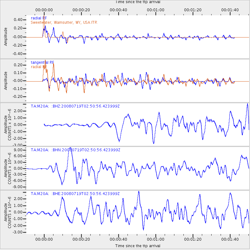
M20A Sweetwater, Wamsutter, WY, USA - Earthquake Result Viewer
| Earthquake location: |
Off East Coast Of Honshu, Japan |
| Earthquake latitude/longitude: |
37.6/142.2 |
| Earthquake time(UTC): |
2008/07/19 (201) 02:39:28 GMT |
| Earthquake Depth: |
22 km |
| Earthquake Magnitude: |
6.2 MB, 7.0 MS, 7.0 MW, 6.9 MW |
| Earthquake Catalog/Contributor: |
WHDF/NEIC |
|
| Network: |
TA USArray Transportable Network (new EarthScope stations) |
| Station: |
M20A Sweetwater, Wamsutter, WY, USA |
| Lat/Lon: |
41.49 N/108.19 W |
| Elevation: |
2134 m |
|
| Distance: |
78.4 deg |
| Az: |
46.251 deg |
| Baz: |
310.164 deg |
| Ray Param: |
0.04961245 |
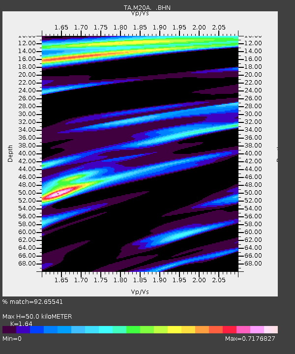
| Estimated Moho Depth: |
50.0 km |
| Estimated Crust Vp/Vs: |
1.64 |
| Assumed Crust Vp: |
6.207 km/s |
| Estimated Crust Vs: |
3.785 km/s |
| Estimated Crust Poisson's Ratio: |
0.20 |
|
| Radial Match: |
92.65541 % |
| Radial Bump: |
365 |
| Transverse Match: |
79.5085 % |
| Transverse Bump: |
400 |
| SOD ConfigId: |
2504 |
| Insert Time: |
2010-03-06 06:20:36.528 +0000 |
| GWidth: |
2.5 |
| Max Bumps: |
400 |
| Tol: |
0.001 |
|
Signal To Noise
| Channel | StoN | STA | LTA |
| TA:M20A: :BHN:20080719T02:50:56.423999Z | 5.938485 | 7.5837045E-7 | 1.2770435E-7 |
| TA:M20A: :BHE:20080719T02:50:56.423999Z | 1.6475883 | 2.2118803E-7 | 1.3424958E-7 |
| TA:M20A: :BHZ:20080719T02:50:56.423999Z | 2.8638282 | 2.9245288E-7 | 1.0211957E-7 |
| Arrivals |
| Ps | 5.3 SECOND |
| PpPs | 21 SECOND |
| PsPs/PpSs | 26 SECOND |


