You are here: Home > Network List > TA - USArray Transportable Network (new EarthScope stations) Stations List
> Station M20A Sweetwater, Wamsutter, WY, USA > Earthquake Result Viewer
M20A Sweetwater, Wamsutter, WY, USA - Earthquake Result Viewer

| Earthquake location: |
Tonga Islands |
| Earthquake latitude/longitude: |
-20.8/-174.3 |
| Earthquake time(UTC): |
2009/07/30 (211) 20:05:34 GMT |
| Earthquake Depth: |
10 km |
| Earthquake Magnitude: |
5.9 MB, 5.7 MS, 5.8 MW, 5.7 MW |
| Earthquake Catalog/Contributor: |
WHDF/NEIC |
|
| Network: |
TA USArray Transportable Network (new EarthScope stations) |
| Station: |
M20A Sweetwater, Wamsutter, WY, USA |
| Lat/Lon: |
41.49 N/108.19 W |
| Elevation: |
2134 m |
|
| Distance: |
87.0 deg |
| Az: |
43.439 deg |
| Baz: |
238.874 deg |
| Ray Param: |
0.043608103 |
| Estimated Moho Depth: |
12.25 km |
| Estimated Crust Vp/Vs: |
2.08 |
| Assumed Crust Vp: |
6.207 km/s |
| Estimated Crust Vs: |
2.991 km/s |
| Estimated Crust Poisson's Ratio: |
0.35 |
|
| Radial Match: |
84.445526 % |
| Radial Bump: |
400 |
| Transverse Match: |
75.28969 % |
| Transverse Bump: |
400 |
| SOD ConfigId: |
2622 |
| Insert Time: |
2010-03-06 06:20:48.731 +0000 |
| GWidth: |
2.5 |
| Max Bumps: |
400 |
| Tol: |
0.001 |
|
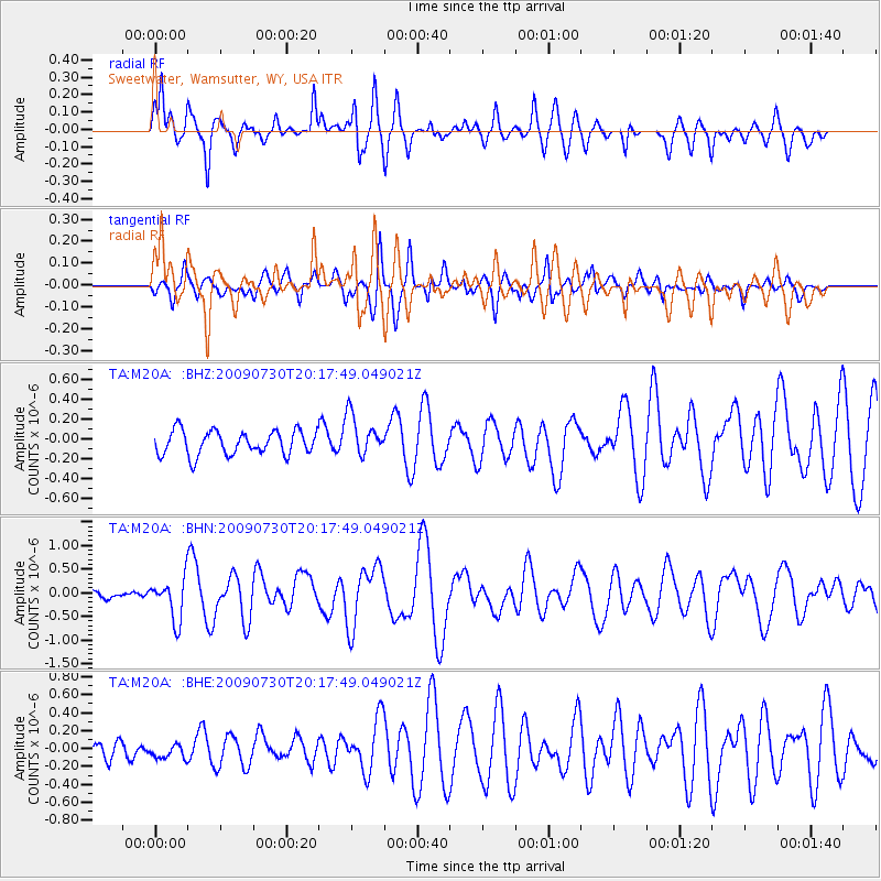
Signal To Noise
| Channel | StoN | STA | LTA |
| TA:M20A: :BHN:20090730T20:17:49.049021Z | 5.4804792 | 4.3524003E-7 | 7.941642E-8 |
| TA:M20A: :BHE:20090730T20:17:49.049021Z | 0.69711244 | 8.399294E-8 | 1.2048693E-7 |
| TA:M20A: :BHZ:20090730T20:17:49.049021Z | 1.6841967 | 2.0530919E-7 | 1.2190333E-7 |
| Arrivals |
| Ps | 2.2 SECOND |
| PpPs | 6.0 SECOND |
| PsPs/PpSs | 8.1 SECOND |


