You are here: Home > Network List > TA - USArray Transportable Network (new EarthScope stations) Stations List
> Station M20A Sweetwater, Wamsutter, WY, USA > Earthquake Result Viewer
M20A Sweetwater, Wamsutter, WY, USA - Earthquake Result Viewer
| Earthquake location: |
Sea Of Okhotsk |
| Earthquake latitude/longitude: |
54.2/154.3 |
| Earthquake time(UTC): |
2008/11/24 (329) 09:02:58 GMT |
| Earthquake Depth: |
492 km |
| Earthquake Magnitude: |
6.5 MB, 7.3 MW, 7.3 MW |
| Earthquake Catalog/Contributor: |
WHDF/NEIC |
|
| Network: |
TA USArray Transportable Network (new EarthScope stations) |
| Station: |
M20A Sweetwater, Wamsutter, WY, USA |
| Lat/Lon: |
41.49 N/108.19 W |
| Elevation: |
2134 m |
|
| Distance: |
61.5 deg |
| Az: |
57.913 deg |
| Baz: |
318.505 deg |
| Ray Param: |
0.0589871 |
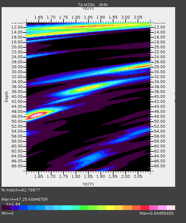
| Estimated Moho Depth: |
47.25 km |
| Estimated Crust Vp/Vs: |
1.64 |
| Assumed Crust Vp: |
6.207 km/s |
| Estimated Crust Vs: |
3.785 km/s |
| Estimated Crust Poisson's Ratio: |
0.20 |
|
| Radial Match: |
82.78977 % |
| Radial Bump: |
251 |
| Transverse Match: |
60.26985 % |
| Transverse Bump: |
309 |
| SOD ConfigId: |
2658 |
| Insert Time: |
2010-03-06 06:21:05.373 +0000 |
| GWidth: |
2.5 |
| Max Bumps: |
400 |
| Tol: |
0.001 |
|
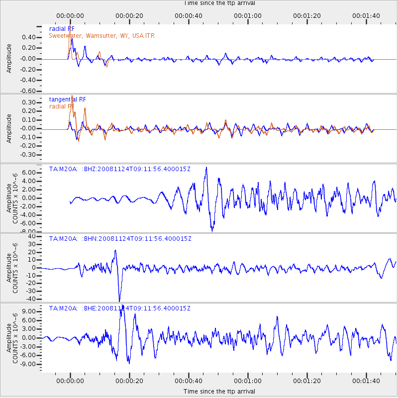
Signal To Noise
| Channel | StoN | STA | LTA |
| TA:M20A: :BHN:20081124T09:11:56.400015Z | 10.060006 | 3.9254373E-6 | 3.902023E-7 |
| TA:M20A: :BHE:20081124T09:11:56.400015Z | 1.4925786 | 6.656573E-7 | 4.4597803E-7 |
| TA:M20A: :BHZ:20081124T09:11:56.400015Z | 2.9025998 | 1.218766E-6 | 4.1988773E-7 |
| Arrivals |
| Ps | 5.1 SECOND |
| PpPs | 19 SECOND |
| PsPs/PpSs | 24 SECOND |


