You are here: Home > Network List > TA - USArray Transportable Network (new EarthScope stations) Stations List
> Station M20A Sweetwater, Wamsutter, WY, USA > Earthquake Result Viewer
M20A Sweetwater, Wamsutter, WY, USA - Earthquake Result Viewer

| Earthquake location: |
Kodiak Island Region, Alaska |
| Earthquake latitude/longitude: |
56.5/-152.7 |
| Earthquake time(UTC): |
2009/03/30 (089) 07:13:07 GMT |
| Earthquake Depth: |
21 km |
| Earthquake Magnitude: |
5.9 MB, 5.9 MS, 5.9 MW, 5.9 MW |
| Earthquake Catalog/Contributor: |
WHDF/NEIC |
|
| Network: |
TA USArray Transportable Network (new EarthScope stations) |
| Station: |
M20A Sweetwater, Wamsutter, WY, USA |
| Lat/Lon: |
41.49 N/108.19 W |
| Elevation: |
2134 m |
|
| Distance: |
32.2 deg |
| Az: |
98.65 deg |
| Baz: |
313.212 deg |
| Ray Param: |
0.07872268 |
| Estimated Moho Depth: |
15.5 km |
| Estimated Crust Vp/Vs: |
1.82 |
| Assumed Crust Vp: |
6.207 km/s |
| Estimated Crust Vs: |
3.42 km/s |
| Estimated Crust Poisson's Ratio: |
0.28 |
|
| Radial Match: |
83.3378 % |
| Radial Bump: |
331 |
| Transverse Match: |
75.49383 % |
| Transverse Bump: |
328 |
| SOD ConfigId: |
2658 |
| Insert Time: |
2010-03-06 06:21:10.009 +0000 |
| GWidth: |
2.5 |
| Max Bumps: |
400 |
| Tol: |
0.001 |
|
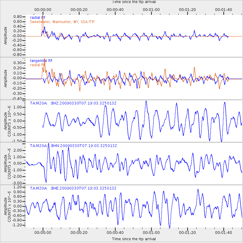
Signal To Noise
| Channel | StoN | STA | LTA |
| TA:M20A: :BHN:20090330T07:19:03.325013Z | 7.453697 | 1.5469049E-6 | 2.0753525E-7 |
| TA:M20A: :BHE:20090330T07:19:03.325013Z | 0.8877327 | 2.7971788E-7 | 3.1509248E-7 |
| TA:M20A: :BHZ:20090330T07:19:03.325013Z | 2.308597 | 7.160409E-7 | 3.101628E-7 |
| Arrivals |
| Ps | 2.2 SECOND |
| PpPs | 6.5 SECOND |
| PsPs/PpSs | 8.7 SECOND |


