You are here: Home > Network List > TA - USArray Transportable Network (new EarthScope stations) Stations List
> Station T25A Trinidad, CO, USA > Earthquake Result Viewer
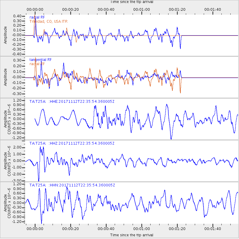
T25A Trinidad, CO, USA - Earthquake Result Viewer
*The percent match for this event was below the threshold and hence no stack was calculated.
| Earthquake location: |
Off East Coast Of Honshu, Japan |
| Earthquake latitude/longitude: |
38.1/144.9 |
| Earthquake time(UTC): |
2017/11/12 (316) 22:24:07 GMT |
| Earthquake Depth: |
9.5 km |
| Earthquake Magnitude: |
5.8 Mww |
| Earthquake Catalog/Contributor: |
NEIC PDE/us |
|
| Network: |
TA USArray Transportable Network (new EarthScope stations) |
| Station: |
T25A Trinidad, CO, USA |
| Lat/Lon: |
37.14 N/104.41 W |
| Elevation: |
2017 m |
|
| Distance: |
81.6 deg |
| Az: |
49.081 deg |
| Baz: |
311.715 deg |
| Ray Param: |
$rayparam |
*The percent match for this event was below the threshold and hence was not used in the summary stack. |
|
| Radial Match: |
53.475647 % |
| Radial Bump: |
310 |
| Transverse Match: |
68.86468 % |
| Transverse Bump: |
369 |
| SOD ConfigId: |
13570011 |
| Insert Time: |
2019-04-29 04:49:50.749 +0000 |
| GWidth: |
2.5 |
| Max Bumps: |
400 |
| Tol: |
0.001 |
|
Signal To Noise
| Channel | StoN | STA | LTA |
| TA:T25A: :HHZ:20171112T22:35:54.360005Z | 4.878817 | 1.410901E-6 | 2.8918913E-7 |
| TA:T25A: :HHN:20171112T22:35:54.360005Z | 1.9510585 | 5.918325E-7 | 3.0333916E-7 |
| TA:T25A: :HHE:20171112T22:35:54.360005Z | 1.8190409 | 5.370127E-7 | 2.9521752E-7 |
| Arrivals |
| Ps | |
| PpPs | |
| PsPs/PpSs | |


