You are here: Home > Network List > TA - USArray Transportable Network (new EarthScope stations) Stations List
> Station M20A Sweetwater, Wamsutter, WY, USA > Earthquake Result Viewer
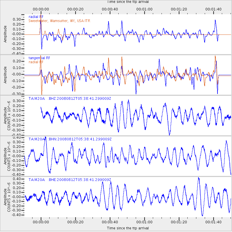
M20A Sweetwater, Wamsutter, WY, USA - Earthquake Result Viewer
*The percent match for this event was below the threshold and hence no stack was calculated.
| Earthquake location: |
Santa Cruz Islands |
| Earthquake latitude/longitude: |
-11.4/166.2 |
| Earthquake time(UTC): |
2008/08/12 (225) 05:25:57 GMT |
| Earthquake Depth: |
38 km |
| Earthquake Magnitude: |
5.9 MW, 5.4 MS, 5.2 MB, 5.8 MW |
| Earthquake Catalog/Contributor: |
WHDF/NEIC |
|
| Network: |
TA USArray Transportable Network (new EarthScope stations) |
| Station: |
M20A Sweetwater, Wamsutter, WY, USA |
| Lat/Lon: |
41.49 N/108.19 W |
| Elevation: |
2134 m |
|
| Distance: |
94.2 deg |
| Az: |
48.682 deg |
| Baz: |
258.562 deg |
| Ray Param: |
$rayparam |
*The percent match for this event was below the threshold and hence was not used in the summary stack. |
|
| Radial Match: |
60.36115 % |
| Radial Bump: |
400 |
| Transverse Match: |
50.708965 % |
| Transverse Bump: |
329 |
| SOD ConfigId: |
2504 |
| Insert Time: |
2010-03-06 06:22:09.472 +0000 |
| GWidth: |
2.5 |
| Max Bumps: |
400 |
| Tol: |
0.001 |
|
Signal To Noise
| Channel | StoN | STA | LTA |
| TA:M20A: :BHN:20080812T05:38:41.299009Z | 2.0564203 | 2.1593111E-7 | 1.05003394E-7 |
| TA:M20A: :BHE:20080812T05:38:41.299009Z | 1.0997186 | 8.753465E-8 | 7.959733E-8 |
| TA:M20A: :BHZ:20080812T05:38:41.299009Z | 1.3407084 | 9.6690705E-8 | 7.211912E-8 |
| Arrivals |
| Ps | |
| PpPs | |
| PsPs/PpSs | |


