You are here: Home > Network List > UW - Pacific Northwest Regional Seismic Network Stations List
> Station UMAT Pilot Rock, OR, USA > Earthquake Result Viewer
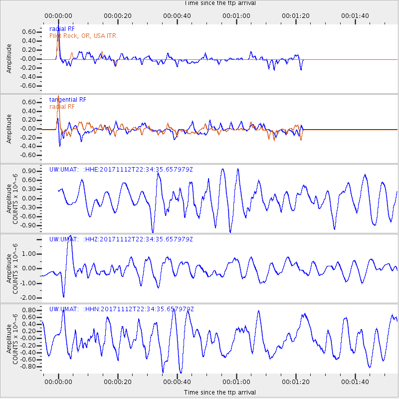
UMAT Pilot Rock, OR, USA - Earthquake Result Viewer
*The percent match for this event was below the threshold and hence no stack was calculated.
| Earthquake location: |
Off East Coast Of Honshu, Japan |
| Earthquake latitude/longitude: |
38.1/144.9 |
| Earthquake time(UTC): |
2017/11/12 (316) 22:24:07 GMT |
| Earthquake Depth: |
9.5 km |
| Earthquake Magnitude: |
5.8 Mww |
| Earthquake Catalog/Contributor: |
NEIC PDE/us |
|
| Network: |
UW Pacific Northwest Regional Seismic Network |
| Station: |
UMAT Pilot Rock, OR, USA |
| Lat/Lon: |
45.29 N/118.96 W |
| Elevation: |
1318 m |
|
| Distance: |
68.0 deg |
| Az: |
49.21 deg |
| Baz: |
302.146 deg |
| Ray Param: |
$rayparam |
*The percent match for this event was below the threshold and hence was not used in the summary stack. |
|
| Radial Match: |
63.037266 % |
| Radial Bump: |
400 |
| Transverse Match: |
72.16369 % |
| Transverse Bump: |
400 |
| SOD ConfigId: |
13570011 |
| Insert Time: |
2019-04-29 04:50:59.447 +0000 |
| GWidth: |
2.5 |
| Max Bumps: |
400 |
| Tol: |
0.001 |
|
Signal To Noise
| Channel | StoN | STA | LTA |
| UW:UMAT: :HHZ:20171112T22:34:35.657979Z | 3.7281394 | 1.312385E-6 | 3.5202146E-7 |
| UW:UMAT: :HHN:20171112T22:34:35.657979Z | 1.2312338 | 4.0027285E-7 | 3.2509897E-7 |
| UW:UMAT: :HHE:20171112T22:34:35.657979Z | 1.9673206 | 5.899084E-7 | 2.9985372E-7 |
| Arrivals |
| Ps | |
| PpPs | |
| PsPs/PpSs | |


