You are here: Home > Network List > AE - Arizona Broadband Seismic Network Stations List
> Station BABIT Valle/Cataract Creek > Earthquake Result Viewer
BABIT Valle/Cataract Creek - Earthquake Result Viewer
| Earthquake location: |
Costa Rica |
| Earthquake latitude/longitude: |
9.5/-84.5 |
| Earthquake time(UTC): |
2017/11/13 (317) 02:28:23 GMT |
| Earthquake Depth: |
19 km |
| Earthquake Magnitude: |
6.5 mww |
| Earthquake Catalog/Contributor: |
NEIC PDE/us |
|
| Network: |
AE Arizona Broadband Seismic Network |
| Station: |
BABIT Valle/Cataract Creek |
| Lat/Lon: |
35.75 N/112.42 W |
| Elevation: |
1694 m |
|
| Distance: |
36.4 deg |
| Az: |
320.093 deg |
| Baz: |
128.928 deg |
| Ray Param: |
0.0766545 |
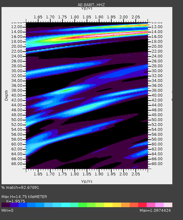
| Estimated Moho Depth: |
14.75 km |
| Estimated Crust Vp/Vs: |
1.96 |
| Assumed Crust Vp: |
6.276 km/s |
| Estimated Crust Vs: |
3.206 km/s |
| Estimated Crust Poisson's Ratio: |
0.32 |
|
| Radial Match: |
92.67891 % |
| Radial Bump: |
176 |
| Transverse Match: |
69.996254 % |
| Transverse Bump: |
400 |
| SOD ConfigId: |
13570011 |
| Insert Time: |
2019-04-29 04:52:23.322 +0000 |
| GWidth: |
2.5 |
| Max Bumps: |
400 |
| Tol: |
0.001 |
|

Signal To Noise
| Channel | StoN | STA | LTA |
| AE:BABIT: :HHZ:20171113T02:34:56.41999Z | 17.64435 | 3.3728847E-6 | 1.9115949E-7 |
| AE:BABIT: :HHN:20171113T02:34:56.41999Z | 6.230873 | 1.2460905E-6 | 1.999865E-7 |
| AE:BABIT: :HHE:20171113T02:34:56.41999Z | 13.73945 | 1.4910684E-6 | 1.085246E-7 |
| Arrivals |
| Ps | 2.4 SECOND |
| PpPs | 6.5 SECOND |
| PsPs/PpSs | 8.9 SECOND |


