You are here: Home > Network List > US - United States National Seismic Network Stations List
> Station HDIL Hopedale, Illinois, USA > Earthquake Result Viewer
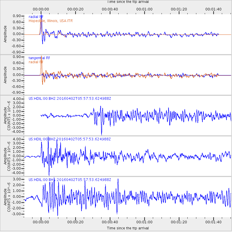
HDIL Hopedale, Illinois, USA - Earthquake Result Viewer
*The percent match for this event was below the threshold and hence no stack was calculated.
| Earthquake location: |
Alaska Peninsula |
| Earthquake latitude/longitude: |
57.0/-158.0 |
| Earthquake time(UTC): |
2016/04/02 (093) 05:50:00 GMT |
| Earthquake Depth: |
10 km |
| Earthquake Magnitude: |
6.2 MWP, 6.4 MI |
| Earthquake Catalog/Contributor: |
NEIC PDE/NEIC COMCAT |
|
| Network: |
US United States National Seismic Network |
| Station: |
HDIL Hopedale, Illinois, USA |
| Lat/Lon: |
40.56 N/89.29 W |
| Elevation: |
219 m |
|
| Distance: |
46.1 deg |
| Az: |
80.26 deg |
| Baz: |
315.005 deg |
| Ray Param: |
$rayparam |
*The percent match for this event was below the threshold and hence was not used in the summary stack. |
|
| Radial Match: |
76.47806 % |
| Radial Bump: |
400 |
| Transverse Match: |
61.340225 % |
| Transverse Bump: |
400 |
| SOD ConfigId: |
1475611 |
| Insert Time: |
2016-04-16 06:34:29.688 +0000 |
| GWidth: |
2.5 |
| Max Bumps: |
400 |
| Tol: |
0.001 |
|
Signal To Noise
| Channel | StoN | STA | LTA |
| US:HDIL:00:BHZ:20160402T05:57:53.624988Z | 15.365486 | 1.8561142E-6 | 1.2079762E-7 |
| US:HDIL:00:BH1:20160402T05:57:53.624988Z | 6.068811 | 1.2385409E-6 | 2.0408297E-7 |
| US:HDIL:00:BH2:20160402T05:57:53.624988Z | 6.2988553 | 1.1222658E-6 | 1.781698E-7 |
| Arrivals |
| Ps | |
| PpPs | |
| PsPs/PpSs | |


