You are here: Home > Network List > AV - Alaska Volcano Observatory Stations List
> Station MAPS Pakushin Southeast, Makushin Volcano, Alaska > Earthquake Result Viewer
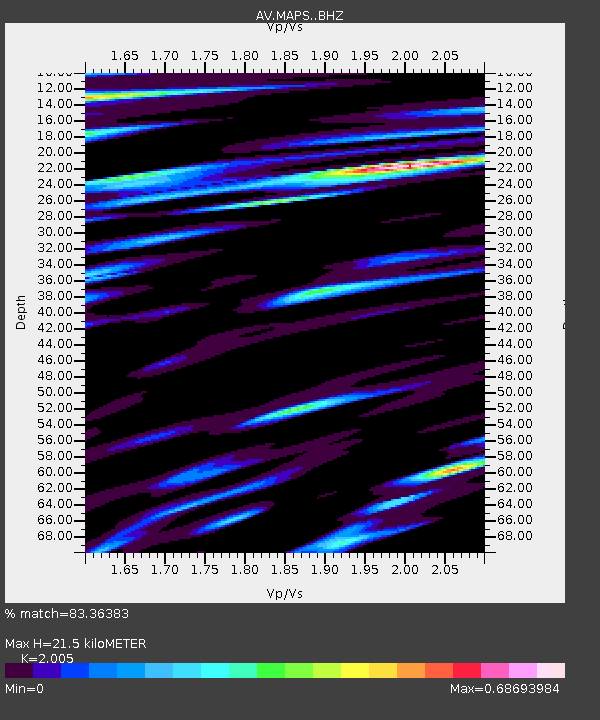
MAPS Pakushin Southeast, Makushin Volcano, Alaska - Earthquake Result Viewer
| Earthquake location: |
Costa Rica |
| Earthquake latitude/longitude: |
9.5/-84.5 |
| Earthquake time(UTC): |
2017/11/13 (317) 02:28:23 GMT |
| Earthquake Depth: |
19 km |
| Earthquake Magnitude: |
6.5 mww |
| Earthquake Catalog/Contributor: |
NEIC PDE/us |
|
| Network: |
AV Alaska Volcano Observatory |
| Station: |
MAPS Pakushin Southeast, Makushin Volcano, Alaska |
| Lat/Lon: |
53.81 N/166.94 W |
| Elevation: |
333 m |
|
| Distance: |
77.9 deg |
| Az: |
323.043 deg |
| Baz: |
90.404 deg |
| Ray Param: |
0.049967792 |
| Estimated Moho Depth: |
21.5 km |
| Estimated Crust Vp/Vs: |
2.01 |
| Assumed Crust Vp: |
3.943 km/s |
| Estimated Crust Vs: |
1.967 km/s |
| Estimated Crust Poisson's Ratio: |
0.33 |
|
| Radial Match: |
83.36383 % |
| Radial Bump: |
400 |
| Transverse Match: |
79.93186 % |
| Transverse Bump: |
400 |
| SOD ConfigId: |
13570011 |
| Insert Time: |
2019-04-29 04:54:04.576 +0000 |
| GWidth: |
2.5 |
| Max Bumps: |
400 |
| Tol: |
0.001 |
|

Signal To Noise
| Channel | StoN | STA | LTA |
| AV:MAPS: :BHZ:20171113T02:39:48.979011Z | 13.107196 | 4.863847E-6 | 3.710822E-7 |
| AV:MAPS: :BHN:20171113T02:39:48.979011Z | 2.0886774 | 6.63004E-7 | 3.1742766E-7 |
| AV:MAPS: :BHE:20171113T02:39:48.979011Z | 2.490072 | 1.4237695E-6 | 5.717784E-7 |
| Arrivals |
| Ps | 5.5 SECOND |
| PpPs | 16 SECOND |
| PsPs/PpSs | 22 SECOND |


