You are here: Home > Network List > AV - Alaska Volcano Observatory Stations List
> Station MNAT Nateekin Bay, Makushin Volcano, Alaska > Earthquake Result Viewer
MNAT Nateekin Bay, Makushin Volcano, Alaska - Earthquake Result Viewer

| Earthquake location: |
Costa Rica |
| Earthquake latitude/longitude: |
9.5/-84.5 |
| Earthquake time(UTC): |
2017/11/13 (317) 02:28:23 GMT |
| Earthquake Depth: |
19 km |
| Earthquake Magnitude: |
6.5 mww |
| Earthquake Catalog/Contributor: |
NEIC PDE/us |
|
| Network: |
AV Alaska Volcano Observatory |
| Station: |
MNAT Nateekin Bay, Makushin Volcano, Alaska |
| Lat/Lon: |
53.88 N/166.69 W |
| Elevation: |
390 m |
|
| Distance: |
77.8 deg |
| Az: |
323.121 deg |
| Baz: |
90.626 deg |
| Ray Param: |
0.05007026 |
| Estimated Moho Depth: |
22.0 km |
| Estimated Crust Vp/Vs: |
1.83 |
| Assumed Crust Vp: |
3.943 km/s |
| Estimated Crust Vs: |
2.161 km/s |
| Estimated Crust Poisson's Ratio: |
0.29 |
|
| Radial Match: |
93.02887 % |
| Radial Bump: |
400 |
| Transverse Match: |
86.10199 % |
| Transverse Bump: |
400 |
| SOD ConfigId: |
13570011 |
| Insert Time: |
2019-04-29 04:54:08.313 +0000 |
| GWidth: |
2.5 |
| Max Bumps: |
400 |
| Tol: |
0.001 |
|
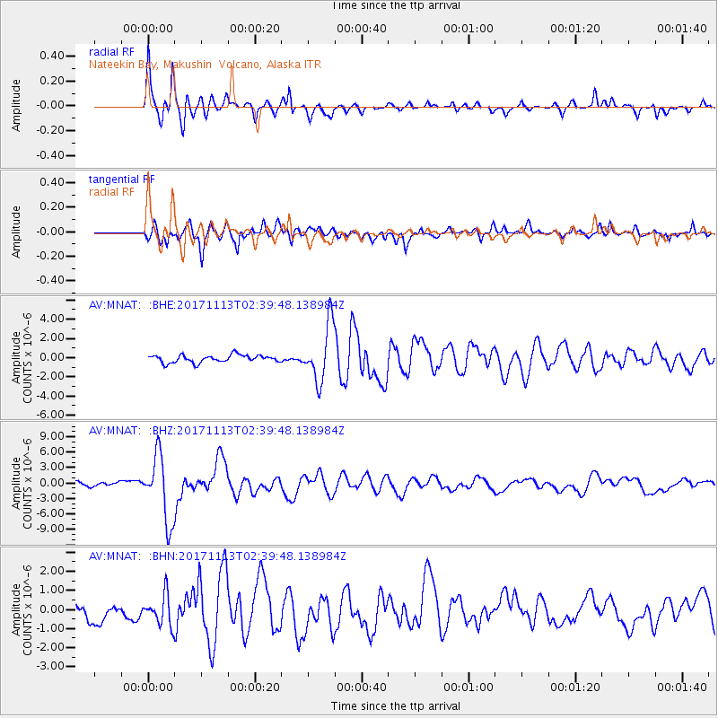
Signal To Noise
| Channel | StoN | STA | LTA |
| AV:MNAT: :BHZ:20171113T02:39:48.138984Z | 18.239077 | 6.560298E-6 | 3.5968367E-7 |
| AV:MNAT: :BHN:20171113T02:39:48.138984Z | 1.9742852 | 8.2934497E-7 | 4.200735E-7 |
| AV:MNAT: :BHE:20171113T02:39:48.138984Z | 7.909898 | 3.0615017E-6 | 3.8704695E-7 |
| Arrivals |
| Ps | 4.7 SECOND |
| PpPs | 16 SECOND |
| PsPs/PpSs | 20 SECOND |


