You are here: Home > Network List > C1 - Red Sismologica Nacional Stations List
> Station MT01 Daracena > Earthquake Result Viewer
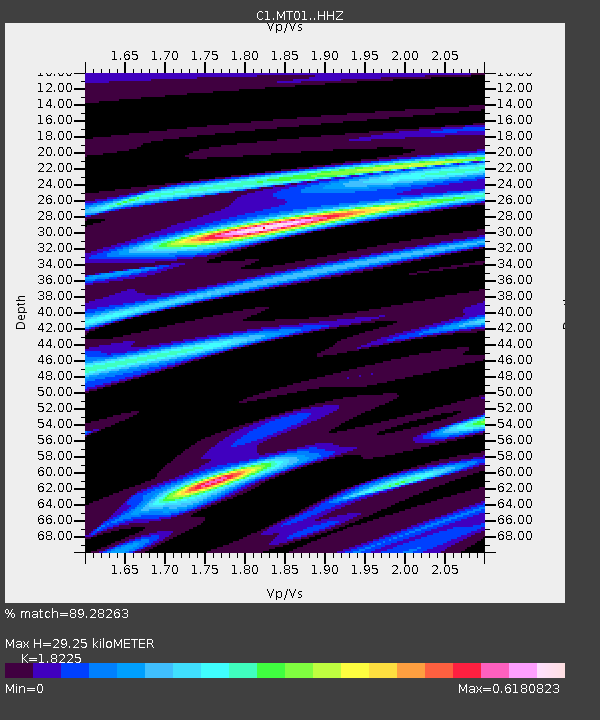
MT01 Daracena - Earthquake Result Viewer
| Earthquake location: |
Costa Rica |
| Earthquake latitude/longitude: |
9.5/-84.5 |
| Earthquake time(UTC): |
2017/11/13 (317) 02:28:23 GMT |
| Earthquake Depth: |
19 km |
| Earthquake Magnitude: |
6.5 mww |
| Earthquake Catalog/Contributor: |
NEIC PDE/us |
|
| Network: |
C1 Red Sismologica Nacional |
| Station: |
MT01 Daracena |
| Lat/Lon: |
33.86 S/71.25 W |
| Elevation: |
310 m |
|
| Distance: |
44.9 deg |
| Az: |
164.352 deg |
| Baz: |
341.352 deg |
| Ray Param: |
0.07158427 |
| Estimated Moho Depth: |
29.25 km |
| Estimated Crust Vp/Vs: |
1.82 |
| Assumed Crust Vp: |
6.481 km/s |
| Estimated Crust Vs: |
3.556 km/s |
| Estimated Crust Poisson's Ratio: |
0.28 |
|
| Radial Match: |
89.28263 % |
| Radial Bump: |
319 |
| Transverse Match: |
71.43918 % |
| Transverse Bump: |
400 |
| SOD ConfigId: |
13570011 |
| Insert Time: |
2019-04-29 04:55:36.207 +0000 |
| GWidth: |
2.5 |
| Max Bumps: |
400 |
| Tol: |
0.001 |
|

Signal To Noise
| Channel | StoN | STA | LTA |
| C1:MT01: :HHZ:20171113T02:36:06.380012Z | 4.345229 | 9.5300067E-7 | 2.1932117E-7 |
| C1:MT01: :HHN:20171113T02:36:06.380012Z | 2.9384086 | 5.290249E-7 | 1.8003787E-7 |
| C1:MT01: :HHE:20171113T02:36:06.380012Z | 1.5328064 | 2.6430718E-7 | 1.724335E-7 |
| Arrivals |
| Ps | 4.0 SECOND |
| PpPs | 12 SECOND |
| PsPs/PpSs | 16 SECOND |


