You are here: Home > Network List > CI - Caltech Regional Seismic Network Stations List
> Station DAN Danby, California, USA > Earthquake Result Viewer
DAN Danby, California, USA - Earthquake Result Viewer
| Earthquake location: |
Costa Rica |
| Earthquake latitude/longitude: |
9.5/-84.5 |
| Earthquake time(UTC): |
2017/11/13 (317) 02:28:23 GMT |
| Earthquake Depth: |
19 km |
| Earthquake Magnitude: |
6.5 mww |
| Earthquake Catalog/Contributor: |
NEIC PDE/us |
|
| Network: |
CI Caltech Regional Seismic Network |
| Station: |
DAN Danby, California, USA |
| Lat/Lon: |
34.64 N/115.38 W |
| Elevation: |
398 m |
|
| Distance: |
37.7 deg |
| Az: |
316.228 deg |
| Baz: |
124.147 deg |
| Ray Param: |
0.075946055 |
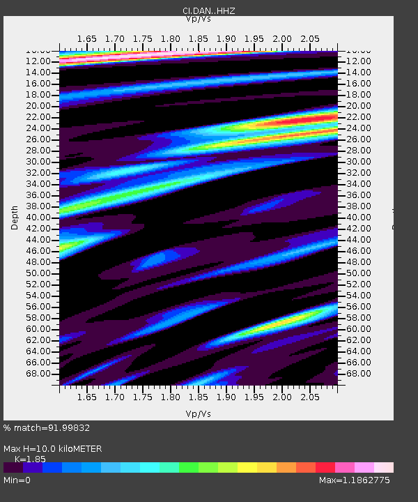
| Estimated Moho Depth: |
10.0 km |
| Estimated Crust Vp/Vs: |
1.85 |
| Assumed Crust Vp: |
6.276 km/s |
| Estimated Crust Vs: |
3.392 km/s |
| Estimated Crust Poisson's Ratio: |
0.29 |
|
| Radial Match: |
91.99832 % |
| Radial Bump: |
400 |
| Transverse Match: |
80.14952 % |
| Transverse Bump: |
400 |
| SOD ConfigId: |
13570011 |
| Insert Time: |
2019-04-29 04:56:13.746 +0000 |
| GWidth: |
2.5 |
| Max Bumps: |
400 |
| Tol: |
0.001 |
|

Signal To Noise
| Channel | StoN | STA | LTA |
| CI:DAN: :HHZ:20171113T02:35:07.347999Z | 13.962274 | 5.334685E-6 | 3.8207853E-7 |
| CI:DAN: :HHN:20171113T02:35:07.347999Z | 6.9417195 | 2.3182408E-6 | 3.3395773E-7 |
| CI:DAN: :HHE:20171113T02:35:07.347999Z | 7.466007 | 2.6448445E-6 | 3.542515E-7 |
| Arrivals |
| Ps | 1.4 SECOND |
| PpPs | 4.2 SECOND |
| PsPs/PpSs | 5.7 SECOND |


