You are here: Home > Network List > TA - USArray Transportable Network (new EarthScope stations) Stations List
> Station K18A Toltan Ranch, Big Piney, WY, USA > Earthquake Result Viewer
K18A Toltan Ranch, Big Piney, WY, USA - Earthquake Result Viewer
| Earthquake location: |
South Of Mariana Islands |
| Earthquake latitude/longitude: |
12.5/143.2 |
| Earthquake time(UTC): |
2008/05/09 (130) 21:51:29 GMT |
| Earthquake Depth: |
76 km |
| Earthquake Magnitude: |
6.1 MB, 6.7 MW, 6.7 MW |
| Earthquake Catalog/Contributor: |
WHDF/NEIC |
|
| Network: |
TA USArray Transportable Network (new EarthScope stations) |
| Station: |
K18A Toltan Ranch, Big Piney, WY, USA |
| Lat/Lon: |
42.64 N/110.04 W |
| Elevation: |
2129 m |
|
| Distance: |
93.6 deg |
| Az: |
45.064 deg |
| Baz: |
290.476 deg |
| Ray Param: |
0.04119195 |
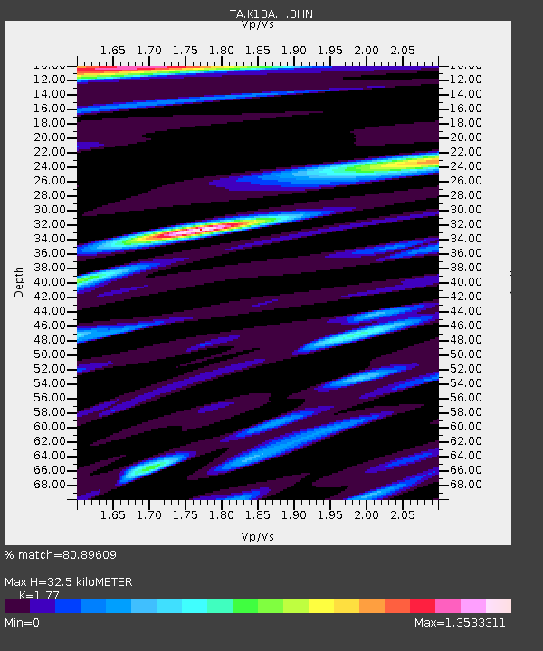
| Estimated Moho Depth: |
32.5 km |
| Estimated Crust Vp/Vs: |
1.77 |
| Assumed Crust Vp: |
6.207 km/s |
| Estimated Crust Vs: |
3.507 km/s |
| Estimated Crust Poisson's Ratio: |
0.27 |
|
| Radial Match: |
80.89609 % |
| Radial Bump: |
400 |
| Transverse Match: |
67.49543 % |
| Transverse Bump: |
400 |
| SOD ConfigId: |
2504 |
| Insert Time: |
2010-03-06 06:24:34.128 +0000 |
| GWidth: |
2.5 |
| Max Bumps: |
400 |
| Tol: |
0.001 |
|

Signal To Noise
| Channel | StoN | STA | LTA |
| TA:K18A: :BHN:20080509T22:04:06.149006Z | 4.129342 | 4.4051063E-7 | 1.06678165E-7 |
| TA:K18A: :BHE:20080509T22:04:06.149006Z | 1.2409303 | 1.4454949E-7 | 1.1648477E-7 |
| TA:K18A: :BHZ:20080509T22:04:06.149006Z | 1.8021067 | 1.7430985E-7 | 9.67256E-8 |
| Arrivals |
| Ps | 4.1 SECOND |
| PpPs | 14 SECOND |
| PsPs/PpSs | 18 SECOND |


