You are here: Home > Network List > US - United States National Seismic Network Stations List
> Station TZTN Tazewell, Tennessee, USA > Earthquake Result Viewer
TZTN Tazewell, Tennessee, USA - Earthquake Result Viewer

| Earthquake location: |
Alaska Peninsula |
| Earthquake latitude/longitude: |
57.0/-158.0 |
| Earthquake time(UTC): |
2016/04/02 (093) 05:50:00 GMT |
| Earthquake Depth: |
10 km |
| Earthquake Magnitude: |
6.2 MWP, 6.4 MI |
| Earthquake Catalog/Contributor: |
NEIC PDE/NEIC COMCAT |
|
| Network: |
US United States National Seismic Network |
| Station: |
TZTN Tazewell, Tennessee, USA |
| Lat/Lon: |
36.54 N/83.55 W |
| Elevation: |
394 m |
|
| Distance: |
52.1 deg |
| Az: |
79.572 deg |
| Baz: |
318.123 deg |
| Ray Param: |
0.067001246 |
| Estimated Moho Depth: |
13.75 km |
| Estimated Crust Vp/Vs: |
1.95 |
| Assumed Crust Vp: |
6.476 km/s |
| Estimated Crust Vs: |
3.33 km/s |
| Estimated Crust Poisson's Ratio: |
0.32 |
|
| Radial Match: |
81.127556 % |
| Radial Bump: |
400 |
| Transverse Match: |
66.53089 % |
| Transverse Bump: |
400 |
| SOD ConfigId: |
1475611 |
| Insert Time: |
2016-04-16 06:38:09.820 +0000 |
| GWidth: |
2.5 |
| Max Bumps: |
400 |
| Tol: |
0.001 |
|
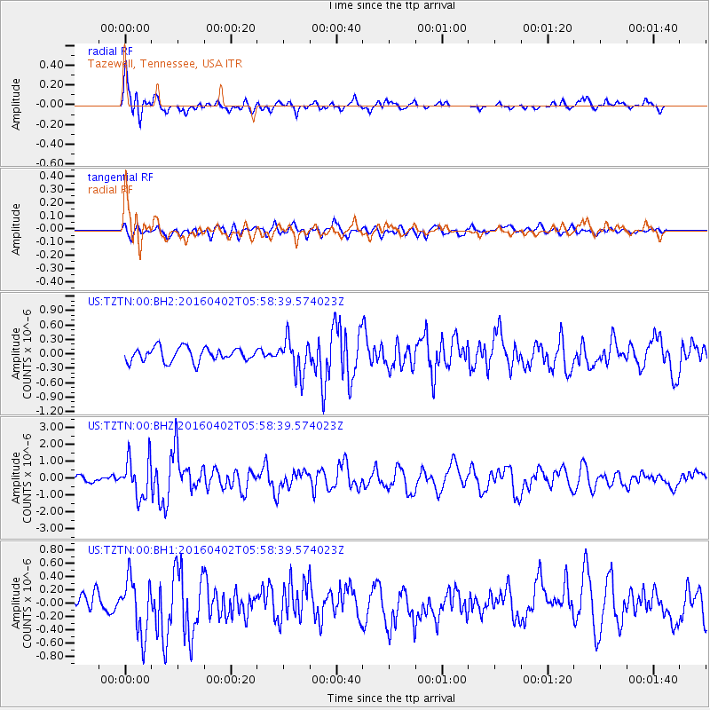
Signal To Noise
| Channel | StoN | STA | LTA |
| US:TZTN:00:BHZ:20160402T05:58:39.574023Z | 6.037806 | 1.1706092E-6 | 1.9387988E-7 |
| US:TZTN:00:BH1:20160402T05:58:39.574023Z | 2.6416142 | 4.2007312E-7 | 1.5902137E-7 |
| US:TZTN:00:BH2:20160402T05:58:39.574023Z | 2.5741653 | 3.662715E-7 | 1.4228748E-7 |
| Arrivals |
| Ps | 2.1 SECOND |
| PpPs | 5.9 SECOND |
| PsPs/PpSs | 8.1 SECOND |


