You are here: Home > Network List > TA - USArray Transportable Network (new EarthScope stations) Stations List
> Station K18A Toltan Ranch, Big Piney, WY, USA > Earthquake Result Viewer
K18A Toltan Ranch, Big Piney, WY, USA - Earthquake Result Viewer
| Earthquake location: |
Tonga Islands |
| Earthquake latitude/longitude: |
-20.8/-173.3 |
| Earthquake time(UTC): |
2008/06/26 (178) 21:19:15 GMT |
| Earthquake Depth: |
38 km |
| Earthquake Magnitude: |
6.0 MB, 5.8 MS, 6.2 MW, 6.1 MW |
| Earthquake Catalog/Contributor: |
WHDF/NEIC |
|
| Network: |
TA USArray Transportable Network (new EarthScope stations) |
| Station: |
K18A Toltan Ranch, Big Piney, WY, USA |
| Lat/Lon: |
42.64 N/110.04 W |
| Elevation: |
2129 m |
|
| Distance: |
85.8 deg |
| Az: |
41.374 deg |
| Baz: |
236.953 deg |
| Ray Param: |
0.044415742 |
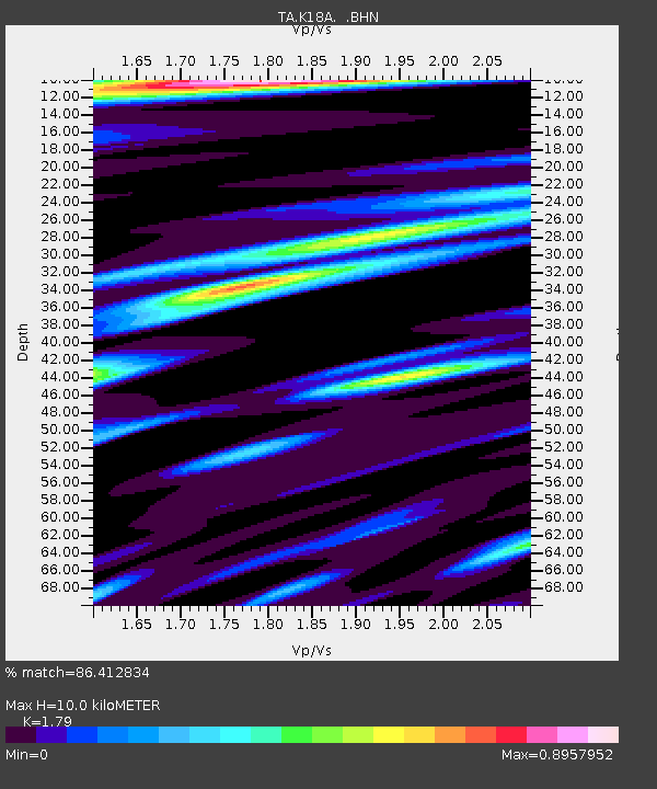
| Estimated Moho Depth: |
10.0 km |
| Estimated Crust Vp/Vs: |
1.79 |
| Assumed Crust Vp: |
6.207 km/s |
| Estimated Crust Vs: |
3.467 km/s |
| Estimated Crust Poisson's Ratio: |
0.27 |
|
| Radial Match: |
86.412834 % |
| Radial Bump: |
400 |
| Transverse Match: |
78.04844 % |
| Transverse Bump: |
400 |
| SOD ConfigId: |
2504 |
| Insert Time: |
2010-03-06 06:24:45.845 +0000 |
| GWidth: |
2.5 |
| Max Bumps: |
400 |
| Tol: |
0.001 |
|
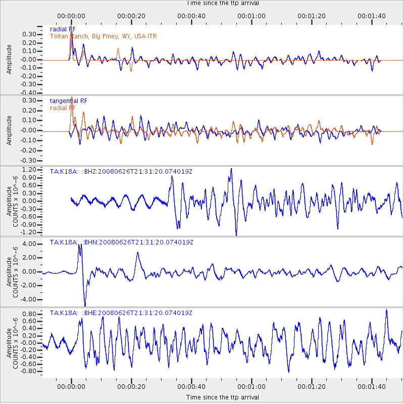
Signal To Noise
| Channel | StoN | STA | LTA |
| TA:K18A: :BHN:20080626T21:31:20.074019Z | 26.438595 | 2.267146E-6 | 8.575139E-8 |
| TA:K18A: :BHE:20080626T21:31:20.074019Z | 2.9407418 | 3.7142837E-7 | 1.2630431E-7 |
| TA:K18A: :BHZ:20080626T21:31:20.074019Z | 2.7419603 | 3.795217E-7 | 1.3841256E-7 |
| Arrivals |
| Ps | 1.3 SECOND |
| PpPs | 4.4 SECOND |
| PsPs/PpSs | 5.7 SECOND |


