You are here: Home > Network List > TA - USArray Transportable Network (new EarthScope stations) Stations List
> Station K18A Toltan Ranch, Big Piney, WY, USA > Earthquake Result Viewer
K18A Toltan Ranch, Big Piney, WY, USA - Earthquake Result Viewer
| Earthquake location: |
Sea Of Okhotsk |
| Earthquake latitude/longitude: |
53.9/152.9 |
| Earthquake time(UTC): |
2008/07/05 (187) 02:12:04 GMT |
| Earthquake Depth: |
633 km |
| Earthquake Magnitude: |
6.8 MB, 7.7 MW, 7.7 MW |
| Earthquake Catalog/Contributor: |
WHDF/NEIC |
|
| Network: |
TA USArray Transportable Network (new EarthScope stations) |
| Station: |
K18A Toltan Ranch, Big Piney, WY, USA |
| Lat/Lon: |
42.64 N/110.04 W |
| Elevation: |
2129 m |
|
| Distance: |
60.7 deg |
| Az: |
57.154 deg |
| Baz: |
317.621 deg |
| Ray Param: |
0.058828365 |
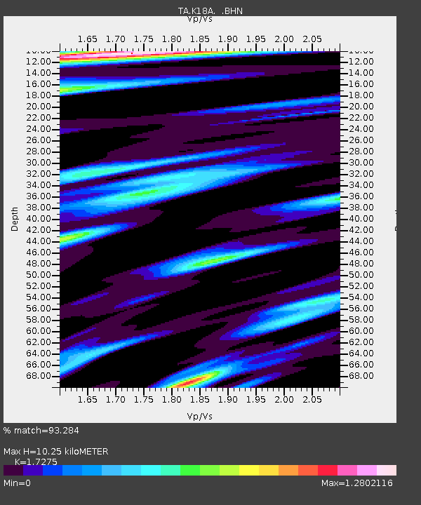
| Estimated Moho Depth: |
10.25 km |
| Estimated Crust Vp/Vs: |
1.73 |
| Assumed Crust Vp: |
6.207 km/s |
| Estimated Crust Vs: |
3.593 km/s |
| Estimated Crust Poisson's Ratio: |
0.25 |
|
| Radial Match: |
93.284 % |
| Radial Bump: |
400 |
| Transverse Match: |
87.34648 % |
| Transverse Bump: |
400 |
| SOD ConfigId: |
2504 |
| Insert Time: |
2010-03-06 06:24:47.258 +0000 |
| GWidth: |
2.5 |
| Max Bumps: |
400 |
| Tol: |
0.001 |
|

Signal To Noise
| Channel | StoN | STA | LTA |
| TA:K18A: :BHN:20080705T02:20:45.474019Z | 58.82774 | 6.073778E-6 | 1.0324683E-7 |
| TA:K18A: :BHE:20080705T02:20:45.474019Z | 7.897161 | 1.5831101E-6 | 2.0046573E-7 |
| TA:K18A: :BHZ:20080705T02:20:45.474019Z | 6.1244364 | 1.4060616E-6 | 2.295822E-7 |
| Arrivals |
| Ps | 1.3 SECOND |
| PpPs | 4.3 SECOND |
| PsPs/PpSs | 5.6 SECOND |


