You are here: Home > Network List > TA - USArray Transportable Network (new EarthScope stations) Stations List
> Station K18A Toltan Ranch, Big Piney, WY, USA > Earthquake Result Viewer
K18A Toltan Ranch, Big Piney, WY, USA - Earthquake Result Viewer

| Earthquake location: |
Off East Coast Of Honshu, Japan |
| Earthquake latitude/longitude: |
37.6/142.2 |
| Earthquake time(UTC): |
2008/07/19 (201) 02:39:28 GMT |
| Earthquake Depth: |
22 km |
| Earthquake Magnitude: |
6.2 MB, 7.0 MS, 7.0 MW, 6.9 MW |
| Earthquake Catalog/Contributor: |
WHDF/NEIC |
|
| Network: |
TA USArray Transportable Network (new EarthScope stations) |
| Station: |
K18A Toltan Ranch, Big Piney, WY, USA |
| Lat/Lon: |
42.64 N/110.04 W |
| Elevation: |
2129 m |
|
| Distance: |
76.7 deg |
| Az: |
46.247 deg |
| Baz: |
308.924 deg |
| Ray Param: |
0.050827067 |
| Estimated Moho Depth: |
31.25 km |
| Estimated Crust Vp/Vs: |
1.82 |
| Assumed Crust Vp: |
6.207 km/s |
| Estimated Crust Vs: |
3.42 km/s |
| Estimated Crust Poisson's Ratio: |
0.28 |
|
| Radial Match: |
87.68223 % |
| Radial Bump: |
400 |
| Transverse Match: |
81.62315 % |
| Transverse Bump: |
400 |
| SOD ConfigId: |
2504 |
| Insert Time: |
2010-03-06 06:24:49.659 +0000 |
| GWidth: |
2.5 |
| Max Bumps: |
400 |
| Tol: |
0.001 |
|
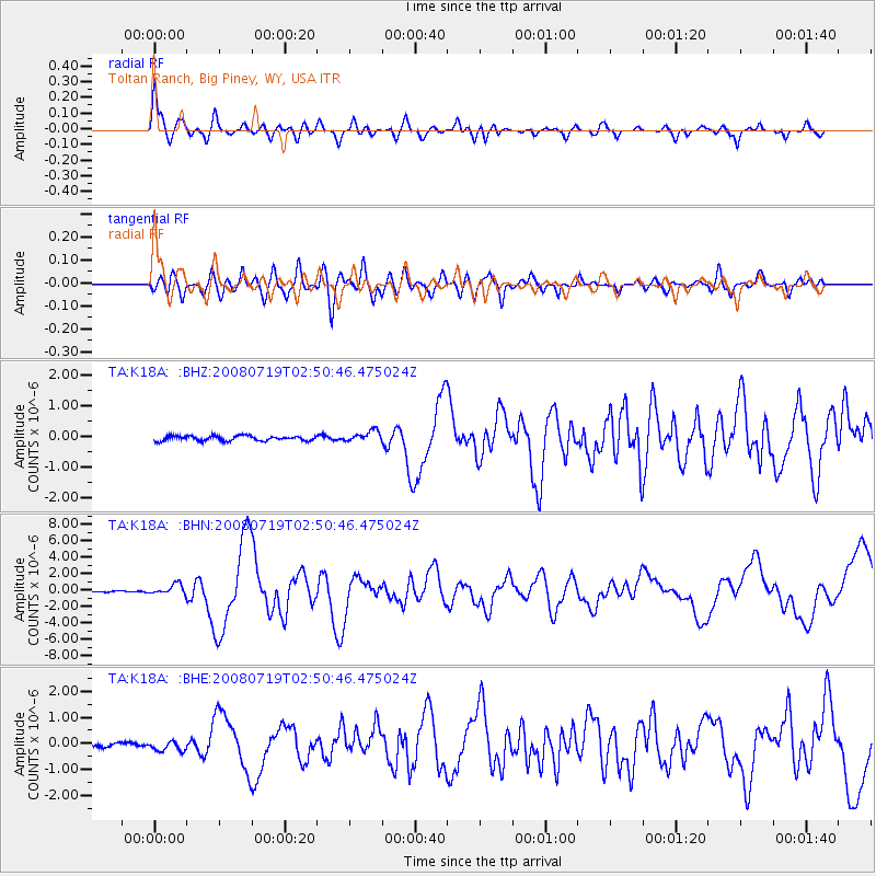
Signal To Noise
| Channel | StoN | STA | LTA |
| TA:K18A: :BHN:20080719T02:50:46.475024Z | 7.16318 | 6.5410507E-7 | 9.13149E-8 |
| TA:K18A: :BHE:20080719T02:50:46.475024Z | 2.1654074 | 1.8851557E-7 | 8.7057785E-8 |
| TA:K18A: :BHZ:20080719T02:50:46.475024Z | 2.299544 | 1.8113246E-7 | 7.8768856E-8 |
| Arrivals |
| Ps | 4.2 SECOND |
| PpPs | 14 SECOND |
| PsPs/PpSs | 18 SECOND |


