You are here: Home > Network List > TA - USArray Transportable Network (new EarthScope stations) Stations List
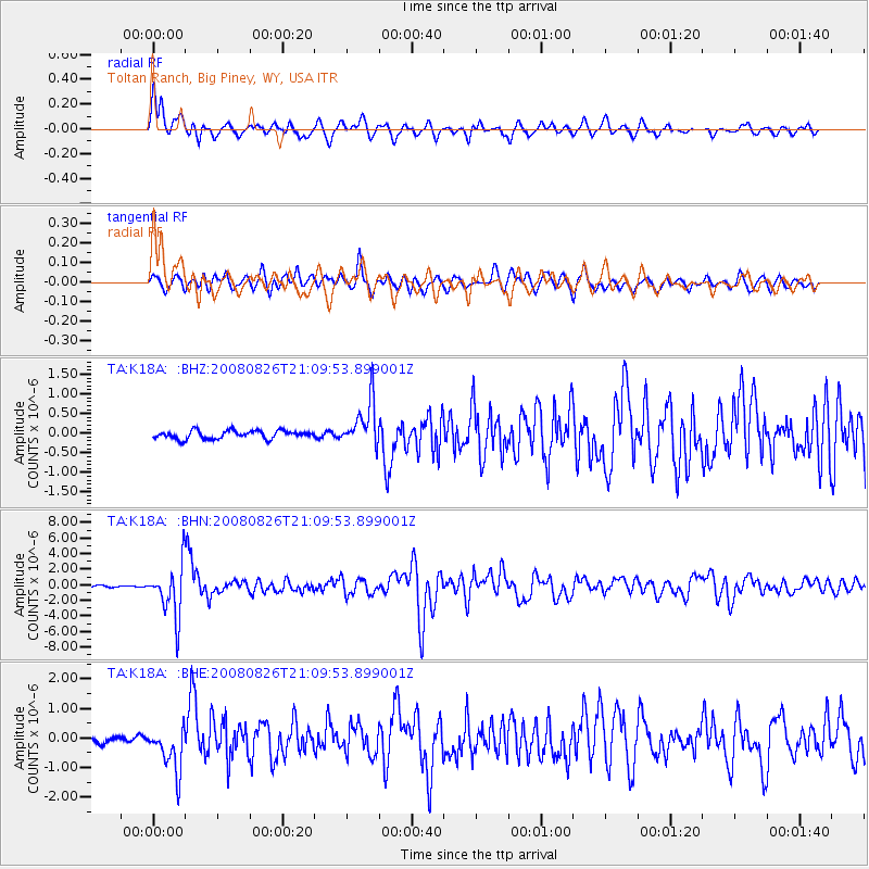
> Station K18A Toltan Ranch, Big Piney, WY, USA > Earthquake Result Viewer
K18A Toltan Ranch, Big Piney, WY, USA - Earthquake Result Viewer
| Earthquake location: |
Peru-Brazil Border Region |
| Earthquake latitude/longitude: |
-7.6/-74.4 |
| Earthquake time(UTC): |
2008/08/26 (239) 21:00:36 GMT |
| Earthquake Depth: |
154 km |
| Earthquake Magnitude: |
6.0 MB, 6.4 MW, 6.4 MW |
| Earthquake Catalog/Contributor: |
WHDF/NEIC |
|
| Network: |
TA USArray Transportable Network (new EarthScope stations) |
| Station: |
K18A Toltan Ranch, Big Piney, WY, USA |
| Lat/Lon: |
42.64 N/110.04 W |
| Elevation: |
2129 m |
|
| Distance: |
59.7 deg |
| Az: |
330.099 deg |
| Baz: |
137.961 deg |
| Ray Param: |
0.061565295 |
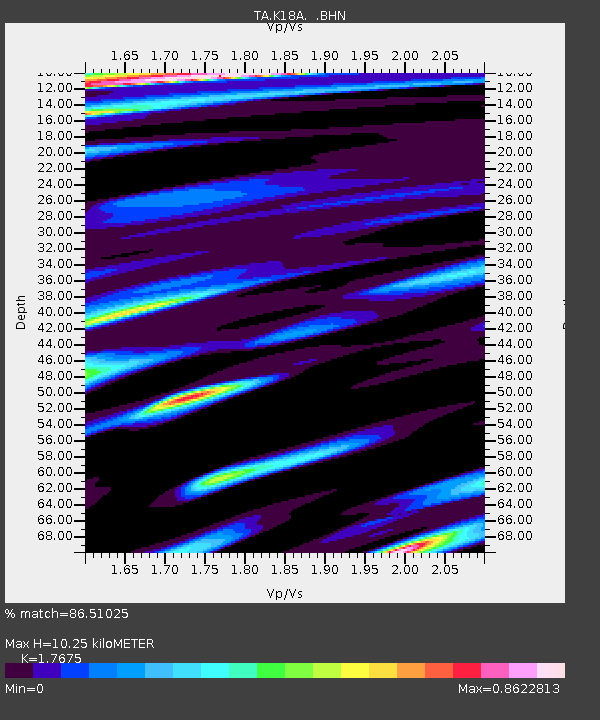
| Estimated Moho Depth: |
10.25 km |
| Estimated Crust Vp/Vs: |
1.77 |
| Assumed Crust Vp: |
6.207 km/s |
| Estimated Crust Vs: |
3.512 km/s |
| Estimated Crust Poisson's Ratio: |
0.26 |
|
| Radial Match: |
86.51025 % |
| Radial Bump: |
400 |
| Transverse Match: |
79.96351 % |
| Transverse Bump: |
400 |
| SOD ConfigId: |
2504 |
| Insert Time: |
2010-03-06 06:24:56.620 +0000 |
| GWidth: |
2.5 |
| Max Bumps: |
400 |
| Tol: |
0.001 |
|
Signal To Noise
| Channel | StoN | STA | LTA |
| TA:K18A: :BHN:20080826T21:09:53.899001Z | 33.291317 | 3.3218587E-6 | 9.978154E-8 |
| TA:K18A: :BHE:20080826T21:09:53.899001Z | 5.5244174 | 7.7580523E-7 | 1.4043205E-7 |
| TA:K18A: :BHZ:20080826T21:09:53.899001Z | 5.5727053 | 5.7336547E-7 | 1.0288817E-7 |
| Arrivals |
| Ps | 1.3 SECOND |
| PpPs | 4.4 SECOND |
| PsPs/PpSs | 5.7 SECOND |


