You are here: Home > Network List > TA - USArray Transportable Network (new EarthScope stations) Stations List
> Station K18A Toltan Ranch, Big Piney, WY, USA > Earthquake Result Viewer
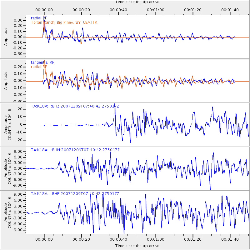
K18A Toltan Ranch, Big Piney, WY, USA - Earthquake Result Viewer

| Earthquake location: |
South Of Fiji Islands |
| Earthquake latitude/longitude: |
-26.0/-177.5 |
| Earthquake time(UTC): |
2007/12/09 (343) 07:28:20 GMT |
| Earthquake Depth: |
152 km |
| Earthquake Magnitude: |
7.0 MB, 7.8 MW, 7.7 MW |
| Earthquake Catalog/Contributor: |
WHDF/NEIC |
|
| Network: |
TA USArray Transportable Network (new EarthScope stations) |
| Station: |
K18A Toltan Ranch, Big Piney, WY, USA |
| Lat/Lon: |
42.64 N/110.04 W |
| Elevation: |
2129 m |
|
| Distance: |
92.3 deg |
| Az: |
43.012 deg |
| Baz: |
236.301 deg |
| Ray Param: |
0.041401643 |
| Estimated Moho Depth: |
42.5 km |
| Estimated Crust Vp/Vs: |
1.64 |
| Assumed Crust Vp: |
6.207 km/s |
| Estimated Crust Vs: |
3.785 km/s |
| Estimated Crust Poisson's Ratio: |
0.20 |
|
| Radial Match: |
91.4787 % |
| Radial Bump: |
400 |
| Transverse Match: |
81.503006 % |
| Transverse Bump: |
400 |
| SOD ConfigId: |
2564 |
| Insert Time: |
2010-03-06 06:25:13.801 +0000 |
| GWidth: |
2.5 |
| Max Bumps: |
400 |
| Tol: |
0.001 |
|
Signal To Noise
| Channel | StoN | STA | LTA |
| TA:K18A: :BHN:20071209T07:40:42.275017Z | 0.8164113 | 2.027734E-7 | 2.4837163E-7 |
| TA:K18A: :BHE:20071209T07:40:42.275017Z | 1.8770206 | 5.045814E-7 | 2.688204E-7 |
| TA:K18A: :BHZ:20071209T07:40:42.275017Z | 4.3585916 | 1.2763809E-6 | 2.9284251E-7 |
| Arrivals |
| Ps | 4.5 SECOND |
| PpPs | 18 SECOND |
| PsPs/PpSs | 22 SECOND |


