You are here: Home > Network List > UU - University of Utah Regional Network Stations List
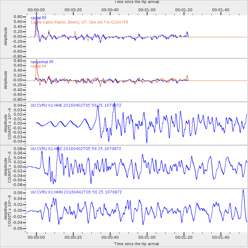
> Station CVRU Castle Valley Ranch, Emery, UT, USA old TA-Q16A > Earthquake Result Viewer
CVRU Castle Valley Ranch, Emery, UT, USA old TA-Q16A - Earthquake Result Viewer
| Earthquake location: |
Alaska Peninsula |
| Earthquake latitude/longitude: |
57.0/-158.0 |
| Earthquake time(UTC): |
2016/04/02 (093) 05:50:00 GMT |
| Earthquake Depth: |
10 km |
| Earthquake Magnitude: |
6.2 MWP, 6.4 MI |
| Earthquake Catalog/Contributor: |
NEIC PDE/NEIC COMCAT |
|
| Network: |
UU University of Utah Regional Network |
| Station: |
CVRU Castle Valley Ranch, Emery, UT, USA old TA-Q16A |
| Lat/Lon: |
38.92 N/111.17 W |
| Elevation: |
1912 m |
|
| Distance: |
35.3 deg |
| Az: |
100.5 deg |
| Baz: |
316.454 deg |
| Ray Param: |
0.07728421 |
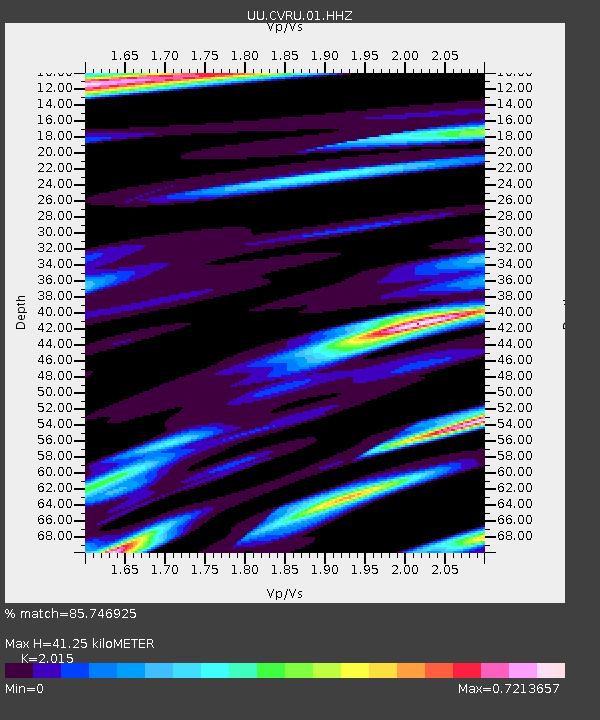
| Estimated Moho Depth: |
41.25 km |
| Estimated Crust Vp/Vs: |
2.02 |
| Assumed Crust Vp: |
6.207 km/s |
| Estimated Crust Vs: |
3.08 km/s |
| Estimated Crust Poisson's Ratio: |
0.34 |
|
| Radial Match: |
85.746925 % |
| Radial Bump: |
300 |
| Transverse Match: |
53.667133 % |
| Transverse Bump: |
381 |
| SOD ConfigId: |
1475611 |
| Insert Time: |
2016-04-16 06:39:15.529 +0000 |
| GWidth: |
2.5 |
| Max Bumps: |
400 |
| Tol: |
0.001 |
|
Signal To Noise
| Channel | StoN | STA | LTA |
| UU:CVRU:01:HHZ:20160402T05:56:25.167987Z | 9.715335 | 2.5147761E-8 | 2.5884606E-9 |
| UU:CVRU:01:HHN:20160402T05:56:25.167987Z | 1.9976087 | 9.880731E-9 | 4.9462794E-9 |
| UU:CVRU:01:HHE:20160402T05:56:25.167987Z | 4.6482735 | 1.769526E-8 | 3.8068455E-9 |
| Arrivals |
| Ps | 7.2 SECOND |
| PpPs | 19 SECOND |
| PsPs/PpSs | 26 SECOND |


