You are here: Home > Network List > TA - USArray Transportable Network (new EarthScope stations) Stations List
> Station C23K Itkillik River, AK, USA > Earthquake Result Viewer
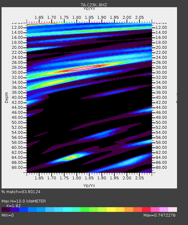
C23K Itkillik River, AK, USA - Earthquake Result Viewer
| Earthquake location: |
Costa Rica |
| Earthquake latitude/longitude: |
9.5/-84.5 |
| Earthquake time(UTC): |
2017/11/13 (317) 02:28:23 GMT |
| Earthquake Depth: |
19 km |
| Earthquake Magnitude: |
6.5 mww |
| Earthquake Catalog/Contributor: |
NEIC PDE/us |
|
| Network: |
TA USArray Transportable Network (new EarthScope stations) |
| Station: |
C23K Itkillik River, AK, USA |
| Lat/Lon: |
69.84 N/150.61 W |
| Elevation: |
179 m |
|
| Distance: |
73.0 deg |
| Az: |
340.635 deg |
| Baz: |
109.392 deg |
| Ray Param: |
0.05327754 |
| Estimated Moho Depth: |
10.0 km |
| Estimated Crust Vp/Vs: |
1.62 |
| Assumed Crust Vp: |
6.221 km/s |
| Estimated Crust Vs: |
3.84 km/s |
| Estimated Crust Poisson's Ratio: |
0.19 |
|
| Radial Match: |
83.90124 % |
| Radial Bump: |
400 |
| Transverse Match: |
77.195 % |
| Transverse Bump: |
400 |
| SOD ConfigId: |
13570011 |
| Insert Time: |
2019-04-29 05:02:20.853 +0000 |
| GWidth: |
2.5 |
| Max Bumps: |
400 |
| Tol: |
0.001 |
|

Signal To Noise
| Channel | StoN | STA | LTA |
| TA:C23K: :BHZ:20171113T02:39:20.724983Z | 8.229067 | 4.539464E-6 | 5.5163775E-7 |
| TA:C23K: :BHN:20171113T02:39:20.724983Z | 1.6046805 | 7.714024E-7 | 4.8072025E-7 |
| TA:C23K: :BHE:20171113T02:39:20.724983Z | 2.7286155 | 1.2415618E-6 | 4.5501528E-7 |
| Arrivals |
| Ps | 1.0 SECOND |
| PpPs | 4.1 SECOND |
| PsPs/PpSs | 5.1 SECOND |


