You are here: Home > Network List > UU - University of Utah Regional Network Stations List
> Station TMU Trail Mountain (BB), UT, USA > Earthquake Result Viewer
TMU Trail Mountain (BB), UT, USA - Earthquake Result Viewer
| Earthquake location: |
Alaska Peninsula |
| Earthquake latitude/longitude: |
57.0/-158.0 |
| Earthquake time(UTC): |
2016/04/02 (093) 05:50:00 GMT |
| Earthquake Depth: |
10 km |
| Earthquake Magnitude: |
6.2 MWP, 6.4 MI |
| Earthquake Catalog/Contributor: |
NEIC PDE/NEIC COMCAT |
|
| Network: |
UU University of Utah Regional Network |
| Station: |
TMU Trail Mountain (BB), UT, USA |
| Lat/Lon: |
39.30 N/111.21 W |
| Elevation: |
2731 m |
|
| Distance: |
35.0 deg |
| Az: |
100.082 deg |
| Baz: |
316.09 deg |
| Ray Param: |
0.07743575 |
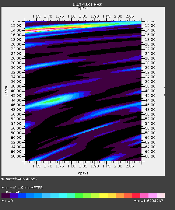
| Estimated Moho Depth: |
14.0 km |
| Estimated Crust Vp/Vs: |
1.64 |
| Assumed Crust Vp: |
6.207 km/s |
| Estimated Crust Vs: |
3.773 km/s |
| Estimated Crust Poisson's Ratio: |
0.21 |
|
| Radial Match: |
85.48557 % |
| Radial Bump: |
400 |
| Transverse Match: |
62.271545 % |
| Transverse Bump: |
400 |
| SOD ConfigId: |
1475611 |
| Insert Time: |
2016-04-16 06:42:45.024 +0000 |
| GWidth: |
2.5 |
| Max Bumps: |
400 |
| Tol: |
0.001 |
|

Signal To Noise
| Channel | StoN | STA | LTA |
| UU:TMU:01:HHZ:20160402T05:56:22.640002Z | 3.745573 | 2.3691305E-8 | 6.325148E-9 |
| UU:TMU:01:HHN:20160402T05:56:22.640002Z | 1.3608267 | 8.730294E-9 | 6.4154335E-9 |
| UU:TMU:01:HHE:20160402T05:56:22.640002Z | 1.3164749 | 1.0303453E-8 | 7.826547E-9 |
| Arrivals |
| Ps | 1.6 SECOND |
| PpPs | 5.5 SECOND |
| PsPs/PpSs | 7.1 SECOND |


