You are here: Home > Network List > TA - USArray Transportable Network (new EarthScope stations) Stations List
> Station G24K Hadweenzic River, AK, USA > Earthquake Result Viewer
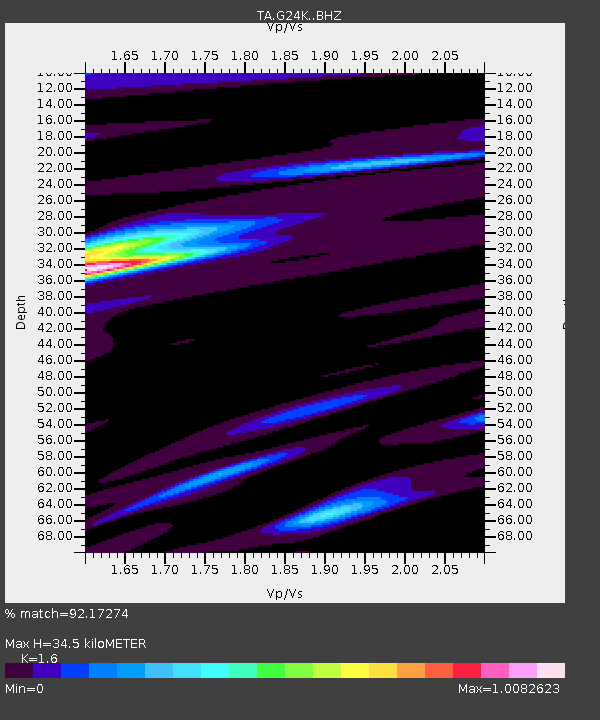
G24K Hadweenzic River, AK, USA - Earthquake Result Viewer
| Earthquake location: |
Costa Rica |
| Earthquake latitude/longitude: |
9.5/-84.5 |
| Earthquake time(UTC): |
2017/11/13 (317) 02:28:23 GMT |
| Earthquake Depth: |
19 km |
| Earthquake Magnitude: |
6.5 mww |
| Earthquake Catalog/Contributor: |
NEIC PDE/us |
|
| Network: |
TA USArray Transportable Network (new EarthScope stations) |
| Station: |
G24K Hadweenzic River, AK, USA |
| Lat/Lon: |
66.70 N/147.48 W |
| Elevation: |
503 m |
|
| Distance: |
70.8 deg |
| Az: |
337.959 deg |
| Baz: |
111.473 deg |
| Ray Param: |
0.05472465 |
| Estimated Moho Depth: |
34.5 km |
| Estimated Crust Vp/Vs: |
1.60 |
| Assumed Crust Vp: |
6.522 km/s |
| Estimated Crust Vs: |
4.076 km/s |
| Estimated Crust Poisson's Ratio: |
0.18 |
|
| Radial Match: |
92.17274 % |
| Radial Bump: |
392 |
| Transverse Match: |
75.69681 % |
| Transverse Bump: |
400 |
| SOD ConfigId: |
13570011 |
| Insert Time: |
2019-04-29 05:02:55.257 +0000 |
| GWidth: |
2.5 |
| Max Bumps: |
400 |
| Tol: |
0.001 |
|

Signal To Noise
| Channel | StoN | STA | LTA |
| TA:G24K: :BHZ:20171113T02:39:07.57502Z | 31.36699 | 3.6954882E-6 | 1.17814565E-7 |
| TA:G24K: :BHN:20171113T02:39:07.57502Z | 3.3703542 | 5.4554954E-7 | 1.6186713E-7 |
| TA:G24K: :BHE:20171113T02:39:07.57502Z | 4.9632297 | 1.2443484E-6 | 2.5071344E-7 |
| Arrivals |
| Ps | 3.3 SECOND |
| PpPs | 13 SECOND |
| PsPs/PpSs | 17 SECOND |


