You are here: Home > Network List > WI - West Indies IPGP Network Stations List
> Station BIM Morne Bigot, Anses d'Arlets, Martinique > Earthquake Result Viewer
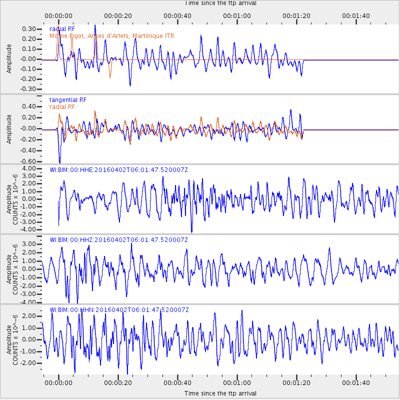
BIM Morne Bigot, Anses d'Arlets, Martinique - Earthquake Result Viewer
*The percent match for this event was below the threshold and hence no stack was calculated.
| Earthquake location: |
Alaska Peninsula |
| Earthquake latitude/longitude: |
57.0/-158.0 |
| Earthquake time(UTC): |
2016/04/02 (093) 05:50:00 GMT |
| Earthquake Depth: |
10 km |
| Earthquake Magnitude: |
6.2 MWP, 6.4 MI |
| Earthquake Catalog/Contributor: |
NEIC PDE/NEIC COMCAT |
|
| Network: |
WI West Indies IPGP Network |
| Station: |
BIM Morne Bigot, Anses d'Arlets, Martinique |
| Lat/Lon: |
14.52 N/61.07 W |
| Elevation: |
391 m |
|
| Distance: |
81.7 deg |
| Az: |
76.355 deg |
| Baz: |
326.739 deg |
| Ray Param: |
$rayparam |
*The percent match for this event was below the threshold and hence was not used in the summary stack. |
|
| Radial Match: |
56.291706 % |
| Radial Bump: |
400 |
| Transverse Match: |
61.798687 % |
| Transverse Bump: |
400 |
| SOD ConfigId: |
1475611 |
| Insert Time: |
2016-04-16 06:43:47.937 +0000 |
| GWidth: |
2.5 |
| Max Bumps: |
400 |
| Tol: |
0.001 |
|
Signal To Noise
| Channel | StoN | STA | LTA |
| WI:BIM:00:HHZ:20160402T06:01:47.520007Z | 3.2583725 | 1.8403591E-6 | 5.648093E-7 |
| WI:BIM:00:HHN:20160402T06:01:47.520007Z | 1.6955451 | 1.0989588E-6 | 6.4814486E-7 |
| WI:BIM:00:HHE:20160402T06:01:47.520007Z | 1.4965831 | 1.71435E-6 | 1.1455094E-6 |
| Arrivals |
| Ps | |
| PpPs | |
| PsPs/PpSs | |


