You are here: Home > Network List > TA - USArray Transportable Network (new EarthScope stations) Stations List
> Station I21K Tanana, AK, USA > Earthquake Result Viewer
I21K Tanana, AK, USA - Earthquake Result Viewer
| Earthquake location: |
Costa Rica |
| Earthquake latitude/longitude: |
9.5/-84.5 |
| Earthquake time(UTC): |
2017/11/13 (317) 02:28:23 GMT |
| Earthquake Depth: |
19 km |
| Earthquake Magnitude: |
6.5 mww |
| Earthquake Catalog/Contributor: |
NEIC PDE/us |
|
| Network: |
TA USArray Transportable Network (new EarthScope stations) |
| Station: |
I21K Tanana, AK, USA |
| Lat/Lon: |
65.18 N/151.98 W |
| Elevation: |
248 m |
|
| Distance: |
72.0 deg |
| Az: |
335.801 deg |
| Baz: |
106.674 deg |
| Ray Param: |
0.053902835 |
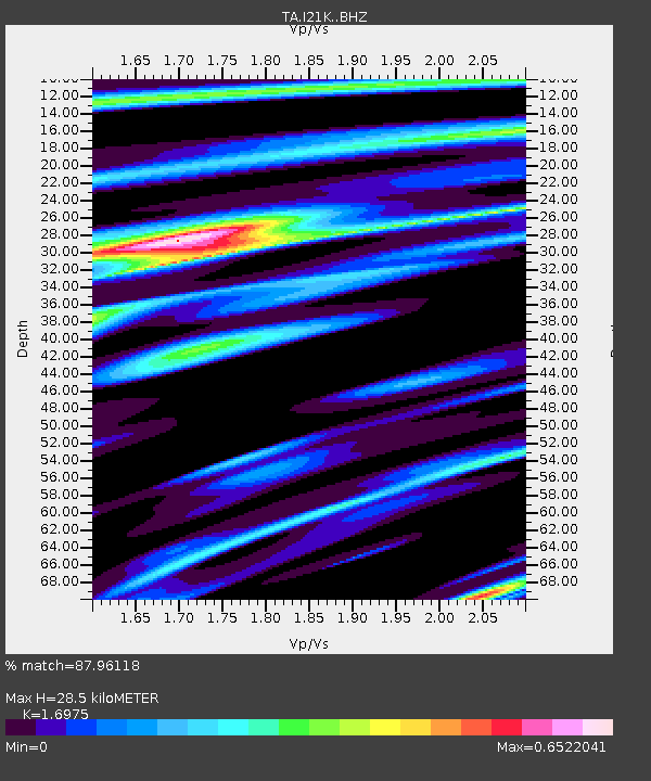
| Estimated Moho Depth: |
28.5 km |
| Estimated Crust Vp/Vs: |
1.70 |
| Assumed Crust Vp: |
6.566 km/s |
| Estimated Crust Vs: |
3.868 km/s |
| Estimated Crust Poisson's Ratio: |
0.23 |
|
| Radial Match: |
87.96118 % |
| Radial Bump: |
400 |
| Transverse Match: |
74.89695 % |
| Transverse Bump: |
400 |
| SOD ConfigId: |
13570011 |
| Insert Time: |
2019-04-29 05:03:11.339 +0000 |
| GWidth: |
2.5 |
| Max Bumps: |
400 |
| Tol: |
0.001 |
|

Signal To Noise
| Channel | StoN | STA | LTA |
| TA:I21K: :BHZ:20171113T02:39:15.099983Z | 20.639513 | 3.4272948E-6 | 1.6605503E-7 |
| TA:I21K: :BHN:20171113T02:39:15.099983Z | 1.9643686 | 6.3074384E-7 | 3.2109241E-7 |
| TA:I21K: :BHE:20171113T02:39:15.099983Z | 4.9971795 | 1.1397493E-6 | 2.2807852E-7 |
| Arrivals |
| Ps | 3.1 SECOND |
| PpPs | 11 SECOND |
| PsPs/PpSs | 14 SECOND |


