You are here: Home > Network List > TA - USArray Transportable Network (new EarthScope stations) Stations List
> Station K15K Wolf Creek Mountain, AK, USA > Earthquake Result Viewer
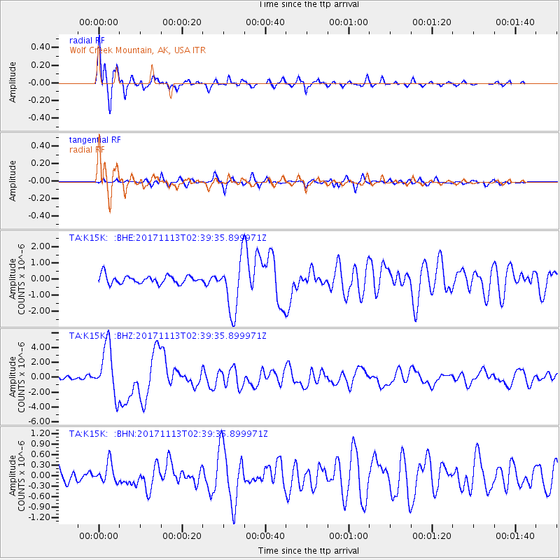
K15K Wolf Creek Mountain, AK, USA - Earthquake Result Viewer
| Earthquake location: |
Costa Rica |
| Earthquake latitude/longitude: |
9.5/-84.5 |
| Earthquake time(UTC): |
2017/11/13 (317) 02:28:23 GMT |
| Earthquake Depth: |
19 km |
| Earthquake Magnitude: |
6.5 mww |
| Earthquake Catalog/Contributor: |
NEIC PDE/us |
|
| Network: |
TA USArray Transportable Network (new EarthScope stations) |
| Station: |
K15K Wolf Creek Mountain, AK, USA |
| Lat/Lon: |
62.29 N/161.53 W |
| Elevation: |
346 m |
|
| Distance: |
75.6 deg |
| Az: |
331.95 deg |
| Baz: |
97.042 deg |
| Ray Param: |
0.05153605 |
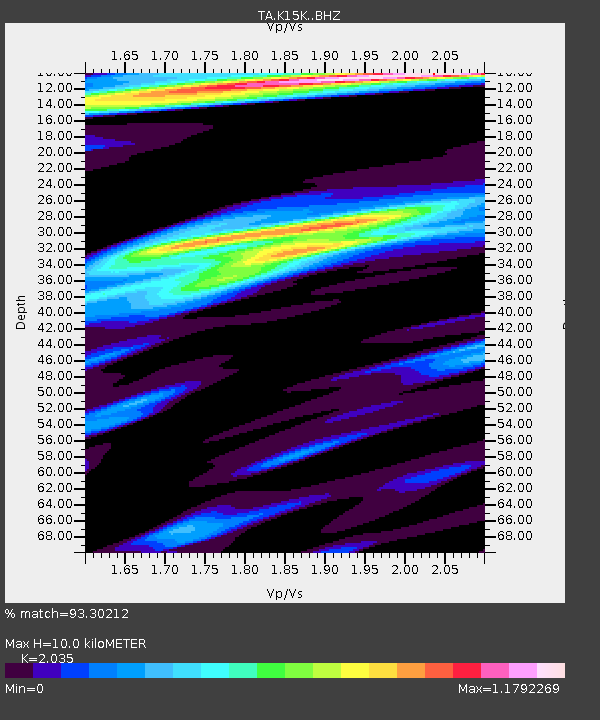
| Estimated Moho Depth: |
10.0 km |
| Estimated Crust Vp/Vs: |
2.04 |
| Assumed Crust Vp: |
6.276 km/s |
| Estimated Crust Vs: |
3.084 km/s |
| Estimated Crust Poisson's Ratio: |
0.34 |
|
| Radial Match: |
93.30212 % |
| Radial Bump: |
400 |
| Transverse Match: |
71.90679 % |
| Transverse Bump: |
400 |
| SOD ConfigId: |
13570011 |
| Insert Time: |
2019-04-29 05:03:23.707 +0000 |
| GWidth: |
2.5 |
| Max Bumps: |
400 |
| Tol: |
0.001 |
|
Signal To Noise
| Channel | StoN | STA | LTA |
| TA:K15K: :BHZ:20171113T02:39:35.899971Z | 18.175812 | 3.4562297E-6 | 1.9015545E-7 |
| TA:K15K: :BHN:20171113T02:39:35.899971Z | 1.0088229 | 2.8796273E-7 | 2.854443E-7 |
| TA:K15K: :BHE:20171113T02:39:35.899971Z | 6.8433642 | 1.7126139E-6 | 2.5025906E-7 |
| Arrivals |
| Ps | 1.7 SECOND |
| PpPs | 4.7 SECOND |
| PsPs/PpSs | 6.4 SECOND |


